Norris geodata
Norris (South Carolina) is a populated place; located in United States in America/New_York (GMT-4) time zone. With population of 819 people, there are 17635 cities with bigger population in this country. Compared to other cities in United States, 76.5% of cities are located further ↑North; 62.7% of cities are located further ←West and 73.6% of cities have lower elevation than Norris. Note1


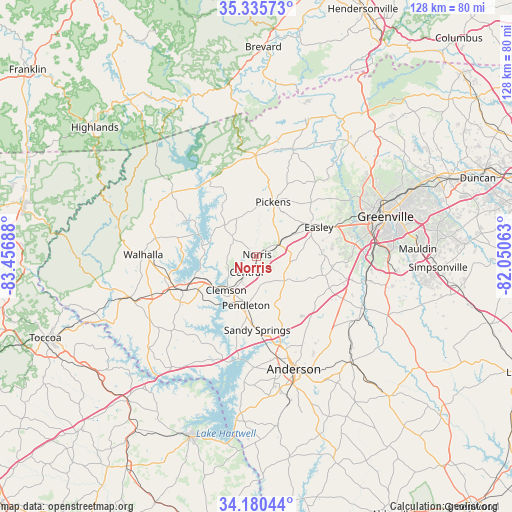
Norris GPS coordinates[2]
34° 45' 36.396" North, 82° 45' 13.5" West
| Map corner | latitude | longitude |
|---|---|---|
| Upper-left | 35.33573°, | -83.45688° |
| Center: | 34.76011°, | -82.75375° |
| Lower-right: | 34.18044°, | -82.05063° |
| Map W x H: | 128.5×128.5 km | = 79.8×79.8mi |
| max Lat: | 71.29058° ⇑76.5% North |
| Norris: | 34.76011° |
| min Lat: | ⇓23.5% South 19.06759° |
| min Long | Norris | max Long |
| -171.73463° | -82.75375° | -66.98998° |
| W 62.7%⇐ | ⇒37.3% E |
Elevation
Elevation of Norris is 305 m = 1001 ft, and this is 10.2 m = 33 ft above average elevation for this country.
| Max E: |
3189 m = 10463 ft | 26.4% |
| Norris | 305 m 1001 ft | |
| Avg. | 294.8 m = 967 ft | |
Min E: |
-60 m = -197 ft | 73.6% |
See also: United States elevation on elevation.city.
Geographical zone
Norris is located in North temperate zone (between Tropic of Cancer and the Arctic Circle). Distance of this Northern Tropic circle is 1259 km =782.3 mi to South.| Distance of | km | miles | from Norris |
|---|---|---|---|
| North Pole | 6142.1 | 3816.5 | to North |
| Arctic Circle | 3536.2 | 2197.3 | to North |
| Tropic Cancer | 1259 | 782.3 | to South |
| Equator | 3865 | 2401.6 | to South |


Nearby cities:
15 places around Norris: (largest is in red/bold)
• Arial
14 km =8.7 mi,  47°
47°
• Centerville
25.8 km =16 mi,  169°
169°
• Central
4.7 km =2.9 mi,  212°
212°
• Clemson
11.4 km =7.1 mi,  221°
221°
• Easley
15.9 km =9.9 mi,  60°
60°
• Liberty
6.4 km =4 mi, 61°
• Northlake
22.5 km =14 mi,  163°
163°
• Pendleton
12.4 km =7.7 mi,  192°
192°
• Pickens
14.4 km =8.9 mi,  17°
17°
• Piedmont
27.2 km =16.9 mi,  103°
103°
• Powdersville
24.1 km =15 mi,  81°
81°
• Seneca
20 km =12.4 mi,  245°
245°
• Six Mile
8.1 km =5 mi,  310°
310°
• Utica
18.6 km =11.6 mi,  240°
240°
• Walhalla
28.3 km =17.6 mi,  271°
271°
Sources, notices
• [Note1] Compared only with cities in United States existing in our database
• [Src1] Map data: © OpenStreetMap contributors (CC-BY-SA)
• [Src2] Other city data from geonames.org with taken over terms of usage.
• [Src3] Geographical zone / Annual Mean Temperature by Robert A. Rohde @ Wikipedia
