Clemson geodata
Clemson (South Carolina) is a populated place; located in United States in America/New_York (GMT-4) time zone. With population of 15,446 people, there are 3157 cities with bigger population in this country. Compared to other cities in United States, 76.9% of cities are located further ↑North; 62.5% of cities are located further ←West and 55.8% of cities have lower elevation than Clemson. Note1


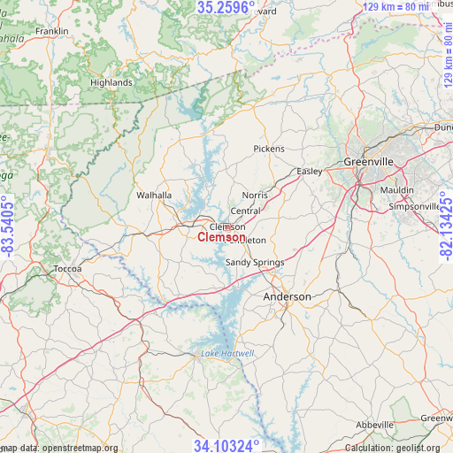
Clemson GPS coordinates[2]
34° 41' 0.384" North, 82° 50' 14.532" West
| Map corner | latitude | longitude |
|---|---|---|
| Upper-left | 35.2596°, | -83.5405° |
| Center: | 34.68344°, | -82.83737° |
| Lower-right: | 34.10324°, | -82.13425° |
| Map W x H: | 128.6×128.6 km | = 79.9×79.9mi |
| max Lat: | 71.29058° ⇑76.9% North |
| Clemson: | 34.68344° |
| min Lat: | ⇓23.1% South 19.06759° |
| min Long | Clemson | max Long |
| -171.73463° | -82.83737° | -66.98998° |
| W 62.5%⇐ | ⇒37.5% E |
Elevation
Elevation of Clemson is 222 m = 728 ft, and this is 72.8 m = 239 ft below average elevation for this country.
| Max E: |
3189 m = 10463 ft | 44.2% |
| Avg. | 294.8 m = 967 ft | |
| Clemson | 222 m = 728 ft | |
Min E: |
-60 m = -197 ft | 55.8% |
See also: United States elevation on elevation.city.
Geographical zone
Clemson is located in North temperate zone (between Tropic of Cancer and the Arctic Circle). Distance of this Northern Tropic circle is 1250.5 km =777 mi to South.| Distance of | km | miles | from Clemson |
|---|---|---|---|
| North Pole | 6150.6 | 3821.8 | to North |
| Arctic Circle | 3544.7 | 2202.6 | to North |
| Tropic Cancer | 1250.5 | 777 | to South |
| Equator | 3856.4 | 2396.3 | to South |


Nearby cities:
15 places around Clemson: (largest is in red/bold)
• Anderson
26.3 km =16.3 mi,  139°
139°
• Arial
25.4 km =15.8 mi,  44°
44°
• Centerville
20.8 km =12.9 mi, 144°
• Central
6.9 km =4.3 mi,  48°
48°
• Fair Play
23.5 km =14.6 mi,  215°
215°
• Liberty
17.6 km =10.9 mi, 48°
• Norris
11.4 km =7.1 mi, 41°
• Northlake
19.2 km =11.9 mi,  132°
132°
• Pendleton
6 km =3.7 mi, 125°
• Pickens
25.2 km =15.7 mi,  28°
28°
• Seneca
10.6 km =6.6 mi,  271°
271°
• Six Mile
13.9 km =8.6 mi,  6°
6°
• Utica
8.6 km =5.3 mi, 266°
• Walhalla
22.6 km =14 mi,  293°
293°
• Westminster
23.8 km =14.8 mi, 265°
Sources, notices
• [Note1] Compared only with cities in United States existing in our database
• [Src1] Map data: © OpenStreetMap contributors (CC-BY-SA)
• [Src2] Other city data from geonames.org with taken over terms of usage.
• [Src3] Geographical zone / Annual Mean Temperature by Robert A. Rohde @ Wikipedia
