Yemassee geodata
Yemassee (South Carolina) is a populated place; located in United States in America/New_York (GMT-4) time zone. With population of 981 people, there are 16400 cities with bigger population in this country. Compared to other cities in United States, 86.5% of cities are located further ↑North; 69.8% of cities are located further ←West and 88.2% of cities have higher elevation than Yemassee. Note1


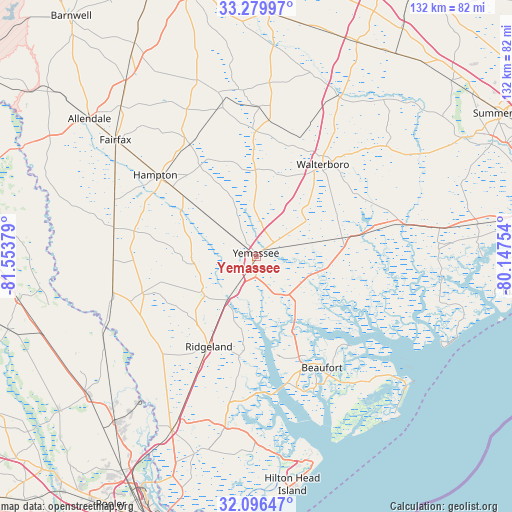
Yemassee GPS coordinates[2]
32° 41' 24.648" North, 80° 51' 2.376" West
| Map corner | latitude | longitude |
|---|---|---|
| Upper-left | 33.27997°, | -81.55379° |
| Center: | 32.69018°, | -80.85066° |
| Lower-right: | 32.09647°, | -80.14754° |
| Map W x H: | 131.6×131.6 km | = 81.8×81.8mi |
| max Lat: | 71.29058° ⇑86.5% North |
| Yemassee: | 32.69018° |
| min Lat: | ⇓13.5% South 19.06759° |
| min Long | Yemassee | max Long |
| -171.73463° | -80.85066° | -66.98998° |
| W 69.8%⇐ | ⇒30.2% E |
Elevation
Elevation of Yemassee is 20 m = 66 ft, and this is 274.8 m = 902 ft below average elevation for this country.
| Max E: |
3189 m = 10463 ft | 88.2% |
| Avg. | 294.8 m = 967 ft | |
| Yemassee | 20 m = 66 ft | |
Min E: |
-60 m = -197 ft | 11.8% |
See also: United States elevation on elevation.city.
Geographical zone
Yemassee is located in North temperate zone (between Tropic of Cancer and the Arctic Circle). Distance of this Northern Tropic circle is 1028.9 km =639.3 mi to South.| Distance of | km | miles | from Yemassee |
|---|---|---|---|
| North Pole | 6372.3 | 3959.6 | to North |
| Arctic Circle | 3766.4 | 2340.3 | to North |
| Tropic Cancer | 1028.9 | 639.3 | to South |
| Equator | 3634.8 | 2258.6 | to South |


Nearby cities:
15 places around Yemassee: (largest is in red/bold)
• Beaufort
33.4 km =20.8 mi,  149°
149°
• Brunson
40.9 km =25.4 mi,  309°
309°
• Burton
30.7 km =19.1 mi,  157°
157°
• Cottageville
44.1 km =27.4 mi,  51°
51°
• Ehrhardt
47.7 km =29.6 mi,  341°
341°
• Estill
37.3 km =23.2 mi,  281°
281°
• Fairfax
46.8 km =29.1 mi, 309°
• Hampton
33.3 km =20.7 mi, 308°
• Hardeeville
49.7 km =30.9 mi,  205°
205°
• Laurel Bay
27.4 km =17 mi,  166°
166°
• Port Royal
37.6 km =23.4 mi, 156°
• Ridgeland
26.3 km =16.3 mi, 207°
• Shell Point
35.8 km =22.2 mi, 162°
• Varnville
27.8 km =17.3 mi, 309°
• Walterboro
29.4 km =18.3 mi,  35°
35°
Sources, notices
• [Note1] Compared only with cities in United States existing in our database
• [Src1] Map data: © OpenStreetMap contributors (CC-BY-SA)
• [Src2] Other city data from geonames.org with taken over terms of usage.
• [Src3] Geographical zone / Annual Mean Temperature by Robert A. Rohde @ Wikipedia
