Beaufort geodata
Beaufort (South Carolina) is a seat of a second-order administrative division; located in United States in America/New_York (GMT-4) time zone. With population of 13,306 people, there are 3594 cities with bigger population in this country. Compared to other cities in United States, 87.4% of cities are located further ↑North; 70.4% of cities are located further ←West and 97.4% of cities have higher elevation than Beaufort. Note1


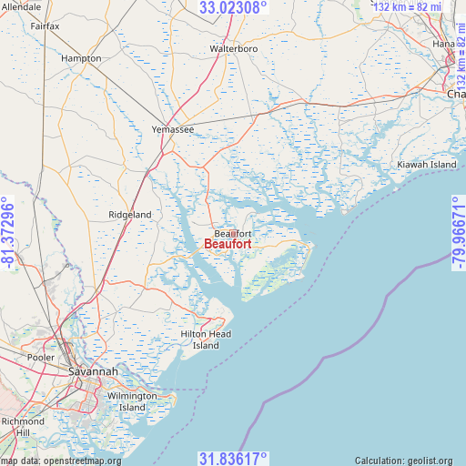
Beaufort GPS coordinates[2]
32° 25' 53.688" North, 80° 40' 11.388" West
| Map corner | latitude | longitude |
|---|---|---|
| Upper-left | 33.02308°, | -81.37296° |
| Center: | 32.43158°, | -80.66983° |
| Lower-right: | 31.83617°, | -79.96671° |
| Map W x H: | 132×132 km | = 82×82mi |
| max Lat: | 71.29058° ⇑87.4% North |
| Beaufort: | 32.43158° |
| min Lat: | ⇓12.6% South 19.06759° |
| min Long | Beaufort | max Long |
| -171.73463° | -80.66983° | -66.98998° |
| W 70.4%⇐ | ⇒29.6% E |
Elevation
Elevation of Beaufort is 6 m = 20 ft, and this is 288.8 m = 948 ft below average elevation for this country.
| Max E: |
3189 m = 10463 ft | 97.4% |
| Avg. | 294.8 m = 967 ft | |
| Beaufort | 6 m = 20 ft | |
Min E: |
-60 m = -197 ft | 2.6% |
See also: United States elevation on elevation.city.
Geographical zone
Beaufort is located in North temperate zone (between Tropic of Cancer and the Arctic Circle). Distance of this Northern Tropic circle is 1000.1 km =621.4 mi to South.| Distance of | km | miles | from Beaufort |
|---|---|---|---|
| North Pole | 6401 | 3977.4 | to North |
| Arctic Circle | 3795.1 | 2358.2 | to North |
| Tropic Cancer | 1000.1 | 621.4 | to South |
| Equator | 3606.1 | 2240.7 | to South |


Nearby cities:
15 places around Beaufort: (largest is in red/bold)
• Bluffton
28.1 km =17.5 mi,  219°
219°
• Burton
5.1 km =3.2 mi,  275°
275°
• Hardeeville
41.8 km =26 mi,  247°
247°
• Hilton Head
25.2 km =15.7 mi,  198°
198°
• Hilton Head Island
27.2 km =16.9 mi,  193°
193°
• Hollywood
52.4 km =32.6 mi,  49°
49°
• Laurel Bay
11 km =6.8 mi, 280°
• Meggett
51.4 km =31.9 mi, 51°
• Port Royal
6.2 km =3.9 mi, 200°
• Ridgeland
29.6 km =18.4 mi, 280°
• Seabrook Island
49.5 km =30.8 mi,  70°
70°
• Shell Point
8.2 km =5.1 mi,  229°
229°
• Tybee Island
50.7 km =31.5 mi, 199°
• Walterboro
52.7 km =32.7 mi,  0°
0°
• Yemassee
33.4 km =20.8 mi,  329°
329°
Sources, notices
• [Note1] Compared only with cities in United States existing in our database
• [Src1] Map data: © OpenStreetMap contributors (CC-BY-SA)
• [Src2] Other city data from geonames.org with taken over terms of usage.
• [Src3] Geographical zone / Annual Mean Temperature by Robert A. Rohde @ Wikipedia
