Bethel Springs geodata
Bethel Springs (Tennessee) is a populated place; located in United States in America/Chicago (GMT-5) time zone. With population of 713 people, there are 18560 cities with bigger population in this country. Compared to other cities in United States, 74.1% of cities are located further ↑North; 55.1% of cities are located further →East and 61.5% of cities have higher elevation than Bethel Springs. Note1


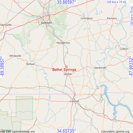
Bethel Springs GPS coordinates[2]
35° 14' 1.284" North, 88° 36' 23.184" West
| Map corner | latitude | longitude |
|---|---|---|
| Upper-left | 35.80597°, | -89.30957° |
| Center: | 35.23369°, | -88.60644° |
| Lower-right: | 34.65735°, | -87.90332° |
| Map W x H: | 127.7×127.7 km | = 79.3×79.3mi |
| max Lat: | 71.29058° ⇑74.1% North |
| Bethel Springs: | 35.23369° |
| min Lat: | ⇓25.9% South 19.06759° |
| min Long | Bethel Springs | max Long |
| -171.73463° | -88.60644° | -66.98998° |
| W 44.9%⇐ | ⇒55.1% E |
Elevation
Elevation of Bethel Springs is 147 m = 482 ft, and this is 147.8 m = 485 ft below average elevation for this country.
| Max E: |
3189 m = 10463 ft | 61.5% |
| Avg. | 294.8 m = 967 ft | |
| Bethel Springs | 147 m = 482 ft | |
Min E: |
-60 m = -197 ft | 38.5% |
See also: United States elevation on elevation.city.
Geographical zone
Bethel Springs is located in North temperate zone (between Tropic of Cancer and the Arctic Circle). Distance of this Northern Tropic circle is 1311.7 km =815.1 mi to South.| Distance of | km | miles | from Bethel Springs |
|---|---|---|---|
| North Pole | 6089.4 | 3783.8 | to North |
| Arctic Circle | 3483.6 | 2164.6 | to North |
| Tropic Cancer | 1311.7 | 815.1 | to South |
| Equator | 3917.6 | 2434.3 | to South |


Nearby cities:
15 places around Bethel Springs: (largest is in red/bold)
• Adamsville
19.6 km =12.2 mi,  89°
89°
• Bolivar
34.7 km =21.6 mi,  274°
274°
• Corinth
34.2 km =21.3 mi,  167°
167°
• Crump
26.2 km =16.3 mi, 92°
• Eastview
18.4 km =11.4 mi,  162°
162°
• Farmington
36.6 km =22.7 mi, 157°
• Henderson
23.1 km =14.4 mi,  352°
352°
• Michie
25.1 km =15.6 mi,  141°
141°
• Middleton
32 km =19.9 mi,  233°
233°
• Olivet
37 km =23 mi, 93°
• Saltillo
39.4 km =24.5 mi,  66°
66°
• Savannah
32.5 km =20.2 mi, 91°
• Scotts Hill
45.3 km =28.1 mi,  46°
46°
• Selmer
7.2 km =4.5 mi, 169°
• Walnut
41.6 km =25.8 mi,  219°
219°
Sources, notices
• [Note1] Compared only with cities in United States existing in our database
• [Src1] Map data: © OpenStreetMap contributors (CC-BY-SA)
• [Src2] Other city data from geonames.org with taken over terms of usage.
• [Src3] Geographical zone / Annual Mean Temperature by Robert A. Rohde @ Wikipedia
