Henderson geodata
Henderson (Tennessee) is a seat of a second-order administrative division; located in United States in America/Chicago (GMT-5) time zone. With population of 6,552 people, there are 6078 cities with bigger population in this country. Compared to other cities in United States, 73% of cities are located further ↑North; 55.2% of cities are located further →East and 63.3% of cities have higher elevation than Henderson. Note1


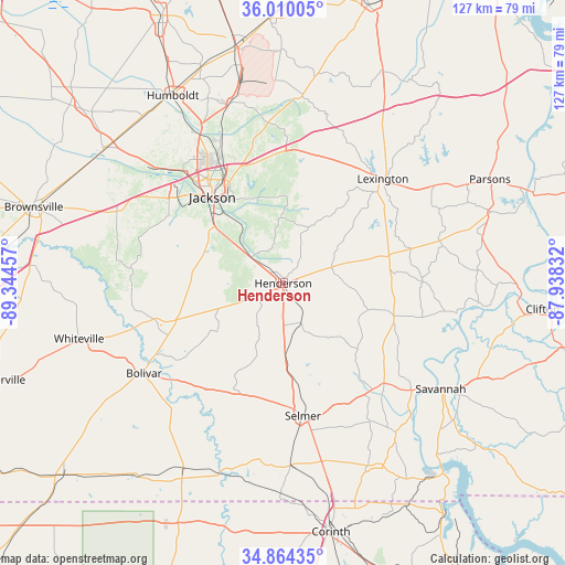
Henderson GPS coordinates[2]
35° 26' 21.264" North, 88° 38' 29.184" West
| Map corner | latitude | longitude |
|---|---|---|
| Upper-left | 36.01005°, | -89.34457° |
| Center: | 35.43924°, | -88.64144° |
| Lower-right: | 34.86435°, | -87.93832° |
| Map W x H: | 127.4×127.4 km | = 79.2×79.2mi |
| max Lat: | 71.29058° ⇑73% North |
| Henderson: | 35.43924° |
| min Lat: | ⇓27% South 19.06759° |
| min Long | Henderson | max Long |
| -171.73463° | -88.64144° | -66.98998° |
| W 44.8%⇐ | ⇒55.2% E |
Elevation
Elevation of Henderson is 137 m = 449 ft, and this is 157.8 m = 518 ft below average elevation for this country.
| Max E: |
3189 m = 10463 ft | 63.3% |
| Avg. | 294.8 m = 967 ft | |
| Henderson | 137 m = 449 ft | |
Min E: |
-60 m = -197 ft | 36.7% |
See also: United States elevation on elevation.city.
Geographical zone
Henderson is located in North temperate zone (between Tropic of Cancer and the Arctic Circle). Distance of this Northern Tropic circle is 1334.6 km =829.3 mi to South.| Distance of | km | miles | from Henderson |
|---|---|---|---|
| North Pole | 6066.6 | 3769.6 | to North |
| Arctic Circle | 3460.7 | 2150.4 | to North |
| Tropic Cancer | 1334.6 | 829.3 | to South |
| Equator | 3940.5 | 2448.5 | to South |


Nearby cities:
15 places around Henderson: (largest is in red/bold)
• Adamsville
32.1 km =19.9 mi,  134°
134°
• Bethel Springs
23.1 km =14.4 mi,  172°
172°
• Bolivar
37.4 km =23.2 mi,  237°
237°
• Crump
38 km =23.6 mi, 129°
• Eastview
41.4 km =25.7 mi, 167°
• Jackson
25 km =15.5 mi,  321°
321°
• Lexington
32.5 km =20.2 mi,  43°
43°
• Medina
42.2 km =26.2 mi,  343°
343°
• Michie
46.5 km =28.9 mi,  156°
156°
• Olivet
47.2 km =29.3 mi,  122°
122°
• Saltillo
39.7 km =24.7 mi,  99°
99°
• Savannah
42.8 km =26.6 mi, 123°
• Scotts Hill
36.8 km =22.9 mi,  76°
76°
• Selmer
30.3 km =18.8 mi, 171°
• Three Way
42.3 km =26.3 mi,  332°
332°
Sources, notices
• [Note1] Compared only with cities in United States existing in our database
• [Src1] Map data: © OpenStreetMap contributors (CC-BY-SA)
• [Src2] Other city data from geonames.org with taken over terms of usage.
• [Src3] Geographical zone / Annual Mean Temperature by Robert A. Rohde @ Wikipedia
