Cross Plains geodata
Cross Plains (Tennessee) is a populated place; located in United States in America/Chicago (GMT-5) time zone. With population of 1,722 people, there are 12839 cities with bigger population in this country. Compared to other cities in United States, 67.9% of cities are located further ↑North; 51% of cities are located further ←West and 56.9% of cities have lower elevation than Cross Plains. Note1


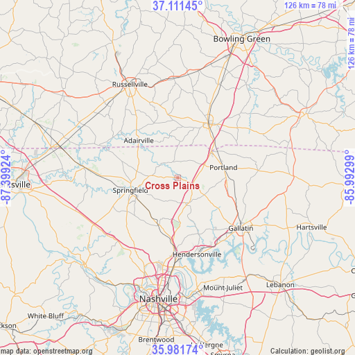
Cross Plains GPS coordinates[2]
36° 32' 55.176" North, 86° 41' 45.996" West
| Map corner | latitude | longitude |
|---|---|---|
| Upper-left | 37.11145°, | -87.39924° |
| Center: | 36.54866°, | -86.69611° |
| Lower-right: | 35.98174°, | -85.99299° |
| Map W x H: | 125.6×125.6 km | = 78×78mi |
| max Lat: | 71.29058° ⇑67.9% North |
| Cross Plains: | 36.54866° |
| min Lat: | ⇓32.1% South 19.06759° |
| min Long | Cross Plains | max Long |
| -171.73463° | -86.69611° | -66.98998° |
| W 51%⇐ | ⇒49% E |
Elevation
Elevation of Cross Plains is 226 m = 741 ft, and this is 68.8 m = 226 ft below average elevation for this country.
| Max E: |
3189 m = 10463 ft | 43.1% |
| Avg. | 294.8 m = 967 ft | |
| Cross Plains | 226 m = 741 ft | |
Min E: |
-60 m = -197 ft | 56.9% |
See also: United States elevation on elevation.city.
Geographical zone
Cross Plains is located in North temperate zone (between Tropic of Cancer and the Arctic Circle). Distance of this Northern Tropic circle is 1457.9 km =905.9 mi to South.| Distance of | km | miles | from Cross Plains |
|---|---|---|---|
| North Pole | 5943.2 | 3692.9 | to North |
| Arctic Circle | 3337.3 | 2073.7 | to North |
| Tropic Cancer | 1457.9 | 905.9 | to South |
| Equator | 4063.8 | 2525.1 | to South |


Nearby cities:
15 places around Cross Plains: (largest is in red/bold)
• Adairville
19.2 km =11.9 mi,  313°
313°
• Coopertown
27.2 km =16.9 mi,  242°
242°
• Franklin
22 km =13.7 mi,  28°
28°
• Gallatin
28.6 km =17.8 mi,  128°
128°
• Goodlettsville
25.1 km =15.6 mi,  183°
183°
• Greenbrier
16.6 km =10.3 mi,  215°
215°
• Hendersonville
28 km =17.4 mi,  165°
165°
• Millersville
19.8 km =12.3 mi, 183°
• Orlinda
6.1 km =3.8 mi,  342°
342°
• Portland
16.5 km =10.3 mi,  77°
77°
• Ridgetop
18.6 km =11.6 mi,  203°
203°
• Shackle Island
21 km =13 mi,  160°
160°
• Springfield
17.4 km =10.8 mi,  255°
255°
• Walnut Grove
10.3 km =6.4 mi, 133°
• White House
9.6 km =6 mi, 155°
Sources, notices
• [Note1] Compared only with cities in United States existing in our database
• [Src1] Map data: © OpenStreetMap contributors (CC-BY-SA)
• [Src2] Other city data from geonames.org with taken over terms of usage.
• [Src3] Geographical zone / Annual Mean Temperature by Robert A. Rohde @ Wikipedia
