Johnson City geodata
Johnson City (Tennessee) is a populated place; located in United States in America/New_York (GMT-4) time zone. With population of 66,027 people, there are 645 cities with bigger population in this country. Compared to other cities in United States, 68.8% of cities are located further ↑North; 64.4% of cities are located further ←West and 87.9% of cities have lower elevation than Johnson City. Note1


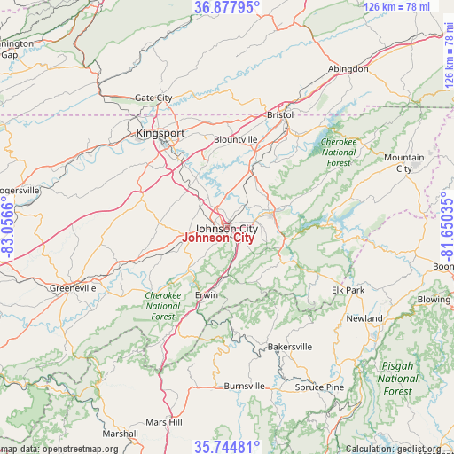
Johnson City GPS coordinates[2]
36° 18' 48.384" North, 82° 21' 12.492" West
| Map corner | latitude | longitude |
|---|---|---|
| Upper-left | 36.87795°, | -83.0566° |
| Center: | 36.31344°, | -82.35347° |
| Lower-right: | 35.74481°, | -81.65035° |
| Map W x H: | 126×126 km | = 78.3×78.3mi |
| max Lat: | 71.29058° ⇑68.8% North |
| Johnson City: | 36.31344° |
| min Lat: | ⇓31.2% South 19.06759° |
| min Long | Johnson City | max Long |
| -171.73463° | -82.35347° | -66.98998° |
| W 64.4%⇐ | ⇒35.6% E |
Elevation
Elevation of Johnson City is 500 m = 1640 ft, and this is 205.2 m = 673 ft above average elevation for this country.
| Max E: |
3189 m = 10463 ft | 12.1% |
| Johnson City | 500 m 1640 ft | |
| Avg. | 294.8 m = 967 ft | |
Min E: |
-60 m = -197 ft | 87.9% |
See also: Johnson City elevation on elevation.city.
Geographical zone
Johnson City is located in North temperate zone (between Tropic of Cancer and the Arctic Circle). Distance of this Northern Tropic circle is 1431.8 km =889.7 mi to South.| Distance of | km | miles | from Johnson City |
|---|---|---|---|
| North Pole | 5969.4 | 3709.2 | to North |
| Arctic Circle | 3363.5 | 2090 | to North |
| Tropic Cancer | 1431.8 | 889.7 | to South |
| Equator | 4037.7 | 2508.9 | to South |


Nearby cities:
15 places around Johnson City: (largest is in red/bold)
• Banner Hill
21.3 km =13.2 mi,  197°
197°
• Bluff City
19.7 km =12.2 mi,  24°
24°
• Central
5.9 km =3.7 mi,  76°
76°
• Colonial Heights
23.3 km =14.5 mi,  324°
324°
• Elizabethton
13.4 km =8.3 mi,  72°
72°
• Erwin
19.6 km =12.2 mi, 196°
• Gray
16.2 km =10.1 mi, 317°
• Hunter
18.6 km =11.6 mi, 69°
• Jonesborough
11 km =6.8 mi,  258°
258°
• Midway
6.5 km =4 mi, 256°
• Oak Grove
12.7 km =7.9 mi,  329°
329°
• Pine Crest
3.6 km =2.2 mi,  116°
116°
• Spurgeon
16.7 km =10.4 mi, 326°
• Telford
18.6 km =11.6 mi,  247°
247°
• Unicoi
13.1 km =8.1 mi,  178°
178°
Sources, notices
• [Note1] Compared only with cities in United States existing in our database
• [Src1] Map data: © OpenStreetMap contributors (CC-BY-SA)
• [Src2] Other city data from geonames.org with taken over terms of usage.
• [Src3] Geographical zone / Annual Mean Temperature by Robert A. Rohde @ Wikipedia
