Gray geodata
Gray (Tennessee) is a populated place; located in United States in America/New_York (GMT-4) time zone. With population of 1,222 people, there are 15001 cities with bigger population in this country. Compared to other cities in United States, 68.4% of cities are located further ↑North; 63.9% of cities are located further ←West and 87.4% of cities have lower elevation than Gray. Note1


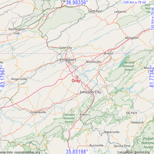
Gray GPS coordinates[2]
36° 25' 11.388" North, 82° 28' 35.544" West
| Map corner | latitude | longitude |
|---|---|---|
| Upper-left | 36.98356°, | -83.17967° |
| Center: | 36.41983°, | -82.47654° |
| Lower-right: | 35.85198°, | -81.77342° |
| Map W x H: | 125.8×125.8 km | = 78.2×78.2mi |
| max Lat: | 71.29058° ⇑68.4% North |
| Gray: | 36.41983° |
| min Lat: | ⇓31.6% South 19.06759° |
| min Long | Gray | max Long |
| -171.73463° | -82.47654° | -66.98998° |
| W 63.9%⇐ | ⇒36.1% E |
Elevation
Elevation of Gray is 483 m = 1585 ft, and this is 188.2 m = 617 ft above average elevation for this country.
| Max E: |
3189 m = 10463 ft | 12.6% |
| Gray | 483 m 1585 ft | |
| Avg. | 294.8 m = 967 ft | |
Min E: |
-60 m = -197 ft | 87.4% |
See also: United States elevation on elevation.city.
Geographical zone
Gray is located in North temperate zone (between Tropic of Cancer and the Arctic Circle). Distance of this Northern Tropic circle is 1443.6 km =897 mi to South.| Distance of | km | miles | from Gray |
|---|---|---|---|
| North Pole | 5957.6 | 3701.9 | to North |
| Arctic Circle | 3351.7 | 2082.6 | to North |
| Tropic Cancer | 1443.6 | 897 | to South |
| Equator | 4049.5 | 2516.2 | to South |


Nearby cities:
15 places around Gray: (largest is in red/bold)
• Bloomingdale
18.4 km =11.4 mi,  356°
356°
• Blountville
18.4 km =11.4 mi,  46°
46°
• Bluff City
20.2 km =12.6 mi,  72°
72°
• Central
19.7 km =12.2 mi,  121°
121°
• Colonial Heights
7.6 km =4.7 mi,  341°
341°
• Fall Branch
13.2 km =8.2 mi,  269°
269°
• Johnson City
16.2 km =10.1 mi,  137°
137°
• Jonesborough
14 km =8.7 mi,  178°
178°
• Kingsport
16.2 km =10.1 mi,  331°
331°
• Midway
14.1 km =8.8 mi,  160°
160°
• Mount Carmel
21.6 km =13.4 mi,  310°
310°
• Oak Grove
4.7 km =2.9 mi,  100°
100°
• Pine Crest
19.5 km =12.1 mi,  133°
133°
• Spurgeon
2.9 km =1.8 mi,  40°
40°
• Telford
20 km =12.4 mi,  197°
197°
Sources, notices
• [Note1] Compared only with cities in United States existing in our database
• [Src1] Map data: © OpenStreetMap contributors (CC-BY-SA)
• [Src2] Other city data from geonames.org with taken over terms of usage.
• [Src3] Geographical zone / Annual Mean Temperature by Robert A. Rohde @ Wikipedia
