Lenoir City geodata
Lenoir City (Tennessee) is a populated place; located in United States in America/New_York (GMT-4) time zone. With population of 9,091 people, there are 4768 cities with bigger population in this country. Compared to other cities in United States, 71.3% of cities are located further ↑North; 58.4% of cities are located further ←West and 62.8% of cities have lower elevation than Lenoir City. Note1


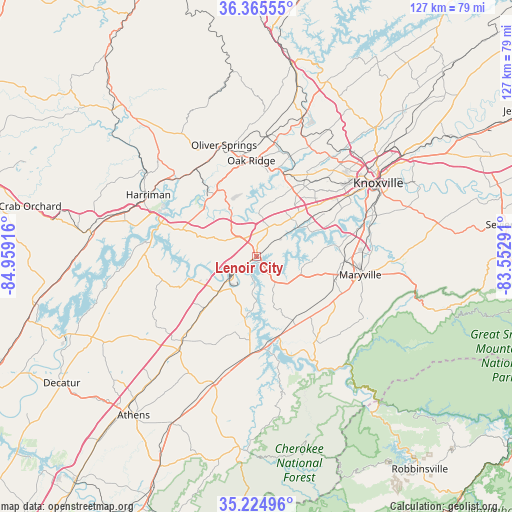
Lenoir City GPS coordinates[2]
35° 47' 50.28" North, 84° 15' 21.708" West
| Map corner | latitude | longitude |
|---|---|---|
| Upper-left | 36.36555°, | -84.95916° |
| Center: | 35.7973°, | -84.25603° |
| Lower-right: | 35.22496°, | -83.55291° |
| Map W x H: | 126.8×126.8 km | = 78.8×78.8mi |
| max Lat: | 71.29058° ⇑71.3% North |
| Lenoir City: | 35.7973° |
| min Lat: | ⇓28.7% South 19.06759° |
| min Long | Lenoir City | max Long |
| -171.73463° | -84.25603° | -66.98998° |
| W 58.4%⇐ | ⇒41.6% E |
Elevation
Elevation of Lenoir City is 252 m = 827 ft, and this is 42.8 m = 140 ft below average elevation for this country.
| Max E: |
3189 m = 10463 ft | 37.2% |
| Avg. | 294.8 m = 967 ft | |
| Lenoir City | 252 m = 827 ft | |
Min E: |
-60 m = -197 ft | 62.8% |
See also: United States elevation on elevation.city.
Geographical zone
Lenoir City is located in North temperate zone (between Tropic of Cancer and the Arctic Circle). Distance of this Northern Tropic circle is 1374.4 km =854 mi to South.| Distance of | km | miles | from Lenoir City |
|---|---|---|---|
| North Pole | 6026.8 | 3744.9 | to North |
| Arctic Circle | 3420.9 | 2125.6 | to North |
| Tropic Cancer | 1374.4 | 854 | to South |
| Equator | 3980.3 | 2473.2 | to South |


Nearby cities:
15 places around Lenoir City: (largest is in red/bold)
• Alcoa
25.5 km =15.8 mi,  91°
91°
• Farragut
13.4 km =8.3 mi,  43°
43°
• Friendsville
11.6 km =7.2 mi,  110°
110°
• Greenback
16.9 km =10.5 mi,  153°
153°
• Huntsville
3.3 km =2.1 mi,  226°
226°
• Kingston
24.6 km =15.3 mi,  292°
292°
• Loudon
10 km =6.2 mi,  224°
224°
• Louisville
19 km =11.8 mi,  81°
81°
• Maryville
26.2 km =16.3 mi,  99°
99°
• Oak Ridge
23.7 km =14.7 mi,  357°
357°
• Philadelphia
18.7 km =11.6 mi, 225°
• Rockford
28.6 km =17.8 mi, 83°
• Sweetwater
28.6 km =17.8 mi, 220°
• Tellico Village
12.7 km =7.9 mi,  179°
179°
• Vonore
23.1 km =14.4 mi, 176°
Sources, notices
• [Note1] Compared only with cities in United States existing in our database
• [Src1] Map data: © OpenStreetMap contributors (CC-BY-SA)
• [Src2] Other city data from geonames.org with taken over terms of usage.
• [Src3] Geographical zone / Annual Mean Temperature by Robert A. Rohde @ Wikipedia
