Rockford geodata
Rockford (Tennessee) is a populated place; located in United States in America/New_York (GMT-4) time zone. With population of 858 people, there are 17307 cities with bigger population in this country. Compared to other cities in United States, 71.2% of cities are located further ↑North; 59.4% of cities are located further ←West and 63.1% of cities have lower elevation than Rockford. Note1


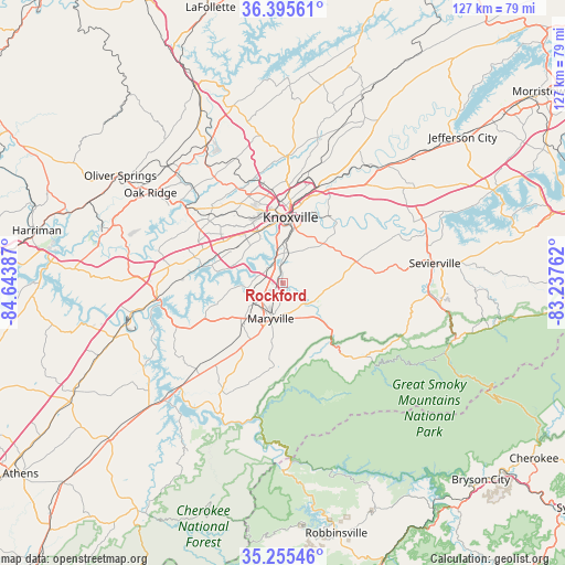
Rockford GPS coordinates[2]
35° 49' 39.288" North, 83° 56' 26.664" West
| Map corner | latitude | longitude |
|---|---|---|
| Upper-left | 36.39561°, | -84.64387° |
| Center: | 35.82758°, | -83.94074° |
| Lower-right: | 35.25546°, | -83.23762° |
| Map W x H: | 126.8×126.8 km | = 78.8×78.8mi |
| max Lat: | 71.29058° ⇑71.2% North |
| Rockford: | 35.82758° |
| min Lat: | ⇓28.8% South 19.06759° |
| min Long | Rockford | max Long |
| -171.73463° | -83.94074° | -66.98998° |
| W 59.4%⇐ | ⇒40.6% E |
Elevation
Elevation of Rockford is 253 m = 830 ft, and this is 41.8 m = 137 ft below average elevation for this country.
| Max E: |
3189 m = 10463 ft | 36.9% |
| Avg. | 294.8 m = 967 ft | |
| Rockford | 253 m = 830 ft | |
Min E: |
-60 m = -197 ft | 63.1% |
See also: United States elevation on elevation.city.
Geographical zone
Rockford is located in North temperate zone (between Tropic of Cancer and the Arctic Circle). Distance of this Northern Tropic circle is 1377.7 km =856.1 mi to South.| Distance of | km | miles | from Rockford |
|---|---|---|---|
| North Pole | 6023.4 | 3742.8 | to North |
| Arctic Circle | 3417.5 | 2123.5 | to North |
| Tropic Cancer | 1377.7 | 856.1 | to South |
| Equator | 3983.7 | 2475.4 | to South |


Nearby cities:
15 places around Rockford: (largest is in red/bold)
• Alcoa
5.2 km =3.2 mi,  215°
215°
• Eagleton Village
3.7 km =2.3 mi,  167°
167°
• Farragut
20.2 km =12.6 mi,  288°
288°
• Friendsville
19.1 km =11.9 mi,  246°
246°
• Greenback
27.9 km =17.3 mi,  228°
228°
• Huntsville
31.3 km =19.4 mi,  259°
259°
• Knoxville
14.9 km =9.3 mi,  6°
6°
• Lenoir City
28.6 km =17.8 mi, 263°
• Louisville
9.7 km =6 mi,  266°
266°
• Maryville
8.3 km =5.2 mi,  198°
198°
• Mascot
31.4 km =19.5 mi,  34°
34°
• Sevierville
34.4 km =21.4 mi,  82°
82°
• Seymour
20.7 km =12.9 mi,  70°
70°
• Tellico Village
32.6 km =20.3 mi,  240°
240°
• Wildwood
6.8 km =4.2 mi,  112°
112°
Sources, notices
• [Note1] Compared only with cities in United States existing in our database
• [Src1] Map data: © OpenStreetMap contributors (CC-BY-SA)
• [Src2] Other city data from geonames.org with taken over terms of usage.
• [Src3] Geographical zone / Annual Mean Temperature by Robert A. Rohde @ Wikipedia
