Lexington geodata
Lexington (Tennessee) is a seat of a second-order administrative division; located in United States in America/Chicago (GMT-5) time zone. With population of 7,822 people, there are 5371 cities with bigger population in this country. Compared to other cities in United States, 72% of cities are located further ↑North; 54.4% of cities are located further →East and 58.8% of cities have higher elevation than Lexington. Note1


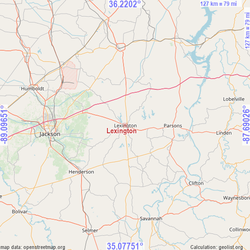
Lexington GPS coordinates[2]
35° 39' 3.24" North, 88° 23' 36.168" West
| Map corner | latitude | longitude |
|---|---|---|
| Upper-left | 36.2202°, | -89.09651° |
| Center: | 35.6509°, | -88.39338° |
| Lower-right: | 35.07751°, | -87.69026° |
| Map W x H: | 127.1×127.1 km | = 79×79mi |
| max Lat: | 71.29058° ⇑72% North |
| Lexington: | 35.6509° |
| min Lat: | ⇓28% South 19.06759° |
| min Long | Lexington | max Long |
| -171.73463° | -88.39338° | -66.98998° |
| W 45.6%⇐ | ⇒54.4% E |
Elevation
Elevation of Lexington is 161 m = 528 ft, and this is 133.8 m = 439 ft below average elevation for this country.
| Max E: |
3189 m = 10463 ft | 58.8% |
| Avg. | 294.8 m = 967 ft | |
| Lexington | 161 m = 528 ft | |
Min E: |
-60 m = -197 ft | 41.2% |
See also: United States elevation on elevation.city.
Geographical zone
Lexington is located in North temperate zone (between Tropic of Cancer and the Arctic Circle). Distance of this Northern Tropic circle is 1358.1 km =843.9 mi to South.| Distance of | km | miles | from Lexington |
|---|---|---|---|
| North Pole | 6043.1 | 3755 | to North |
| Arctic Circle | 3437.2 | 2135.8 | to North |
| Tropic Cancer | 1358.1 | 843.9 | to South |
| Equator | 3964 | 2463.1 | to South |


Nearby cities:
15 places around Lexington: (largest is in red/bold)
• Atwood
44.1 km =27.4 mi,  324°
324°
• Bruceton
45.1 km =28 mi,  17°
17°
• Decaturville
25.8 km =16 mi,  106°
106°
• Henderson
32.5 km =20.2 mi,  223°
223°
• Hollow Rock
44.4 km =27.6 mi,  14°
14°
• Huntingdon
39 km =24.2 mi,  355°
355°
• Jackson
38.2 km =23.7 mi,  263°
263°
• Medina
38.3 km =23.8 mi,  296°
296°
• Milan
44.5 km =27.7 mi,  312°
312°
• Mount Carmel
38.8 km =24.1 mi,  116°
116°
• Parsons
24.1 km =15 mi,  90°
90°
• Saltillo
34.6 km =21.5 mi,  151°
151°
• Scotts Hill
20.2 km =12.6 mi,  138°
138°
• Three Way
44.3 km =27.5 mi,  288°
288°
• Trezevant
45.1 km =28 mi,  332°
332°
Sources, notices
• [Note1] Compared only with cities in United States existing in our database
• [Src1] Map data: © OpenStreetMap contributors (CC-BY-SA)
• [Src2] Other city data from geonames.org with taken over terms of usage.
• [Src3] Geographical zone / Annual Mean Temperature by Robert A. Rohde @ Wikipedia
