Ridgely geodata
Ridgely (Tennessee) is a populated place; located in United States in America/Chicago (GMT-5) time zone. With population of 1,706 people, there are 12888 cities with bigger population in this country. Compared to other cities in United States, 69.1% of cities are located further ↑North; 57.5% of cities are located further →East and 72.8% of cities have higher elevation than Ridgely. Note1


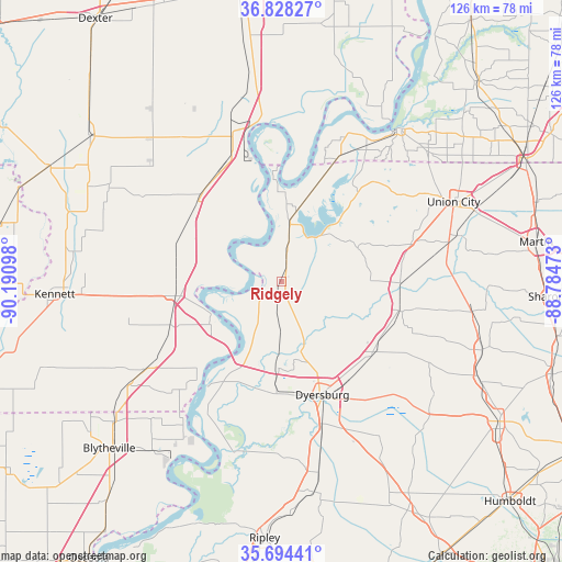
Ridgely GPS coordinates[2]
36° 15' 48.24" North, 89° 29' 16.26" West
| Map corner | latitude | longitude |
|---|---|---|
| Upper-left | 36.82827°, | -90.19098° |
| Center: | 36.2634°, | -89.48785° |
| Lower-right: | 35.69441°, | -88.78473° |
| Map W x H: | 126.1×126.1 km | = 78.4×78.4mi |
| max Lat: | 71.29058° ⇑69.1% North |
| Ridgely: | 36.2634° |
| min Lat: | ⇓30.9% South 19.06759° |
| min Long | Ridgely | max Long |
| -171.73463° | -89.48785° | -66.98998° |
| W 42.5%⇐ | ⇒57.5% E |
Elevation
Elevation of Ridgely is 84 m = 276 ft, and this is 210.8 m = 692 ft below average elevation for this country.
| Max E: |
3189 m = 10463 ft | 72.8% |
| Avg. | 294.8 m = 967 ft | |
| Ridgely | 84 m = 276 ft | |
Min E: |
-60 m = -197 ft | 27.2% |
See also: United States elevation on elevation.city.
Geographical zone
Ridgely is located in North temperate zone (between Tropic of Cancer and the Arctic Circle). Distance of this Northern Tropic circle is 1426.2 km =886.2 mi to South.| Distance of | km | miles | from Ridgely |
|---|---|---|---|
| North Pole | 5974.9 | 3712.6 | to North |
| Arctic Circle | 3369.1 | 2093.5 | to North |
| Tropic Cancer | 1426.2 | 886.2 | to South |
| Equator | 4032.1 | 2505.4 | to South |


Nearby cities:
15 places around Ridgely: (largest is in red/bold)
• Caruthersville
17 km =10.6 mi,  242°
242°
• Dyersburg
27.1 km =16.8 mi,  160°
160°
• Englewood
32 km =19.9 mi,  68°
68°
• Hayti
23.7 km =14.7 mi,  261°
261°
• Hayti Heights
25.5 km =15.8 mi, 262°
• Lilbourn
38.3 km =23.8 mi,  342°
342°
• New Madrid
36.1 km =22.4 mi,  354°
354°
• Newbern
26.3 km =16.3 mi,  129°
129°
• Obion
26.6 km =16.5 mi,  91°
91°
• Portageville
26.1 km =16.2 mi,  313°
313°
• Steele
36.6 km =22.7 mi, 236°
• Tiptonville
12.9 km =8 mi,  6°
6°
• Trimble
27.5 km =17.1 mi,  104°
104°
• Troy
30.2 km =18.8 mi, 73°
• Union City
42.5 km =26.4 mi, 65°
Sources, notices
• [Note1] Compared only with cities in United States existing in our database
• [Src1] Map data: © OpenStreetMap contributors (CC-BY-SA)
• [Src2] Other city data from geonames.org with taken over terms of usage.
• [Src3] Geographical zone / Annual Mean Temperature by Robert A. Rohde @ Wikipedia
