Dyersburg geodata
Dyersburg (Tennessee) is a seat of a second-order administrative division; located in United States in America/Chicago (GMT-5) time zone. With population of 16,781 people, there are 2926 cities with bigger population in this country. Compared to other cities in United States, 70.3% of cities are located further ↑North; 57.3% of cities are located further →East and 70.8% of cities have higher elevation than Dyersburg. Note1


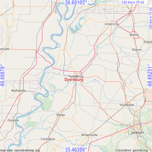
Dyersburg GPS coordinates[2]
36° 2' 4.272" North, 89° 23' 8.268" West
| Map corner | latitude | longitude |
|---|---|---|
| Upper-left | 36.60105°, | -90.08876° |
| Center: | 36.03452°, | -89.38563° |
| Lower-right: | 35.46388°, | -88.68251° |
| Map W x H: | 126.4×126.4 km | = 78.5×78.5mi |
| max Lat: | 71.29058° ⇑70.3% North |
| Dyersburg: | 36.03452° |
| min Lat: | ⇓29.7% South 19.06759° |
| min Long | Dyersburg | max Long |
| -171.73463° | -89.38563° | -66.98998° |
| W 42.7%⇐ | ⇒57.3% E |
Elevation
Elevation of Dyersburg is 96 m = 315 ft, and this is 198.8 m = 652 ft below average elevation for this country.
| Max E: |
3189 m = 10463 ft | 70.8% |
| Avg. | 294.8 m = 967 ft | |
| Dyersburg | 96 m = 315 ft | |
Min E: |
-60 m = -197 ft | 29.2% |
See also: United States elevation on elevation.city.
Geographical zone
Dyersburg is located in North temperate zone (between Tropic of Cancer and the Arctic Circle). Distance of this Northern Tropic circle is 1400.7 km =870.4 mi to South.| Distance of | km | miles | from Dyersburg |
|---|---|---|---|
| North Pole | 6000.4 | 3728.5 | to North |
| Arctic Circle | 3394.5 | 2109.2 | to North |
| Tropic Cancer | 1400.7 | 870.4 | to South |
| Equator | 4006.7 | 2489.6 | to South |


Nearby cities:
15 places around Dyersburg: (largest is in red/bold)
• Alamo
36.8 km =22.9 mi,  138°
138°
• Caruthersville
30 km =18.6 mi,  306°
306°
• Central
29.1 km =18.1 mi,  208°
208°
• Dyer
35.4 km =22 mi,  84°
84°
• Friendship
18.8 km =11.7 mi, 137°
• Gates
21.9 km =13.6 mi,  184°
184°
• Halls
17.7 km =11 mi, 183°
• Kenton
38.4 km =23.9 mi,  60°
60°
• Maury City
28.4 km =17.6 mi,  149°
149°
• Newbern
14.1 km =8.8 mi,  51°
51°
• Obion
30.4 km =18.9 mi,  34°
34°
• Ridgely
27.1 km =16.8 mi,  340°
340°
• Ripley
34.7 km =21.6 mi,  201°
201°
• Rutherford
37.4 km =23.2 mi,  73°
73°
• Trimble
25.6 km =15.9 mi,  43°
43°
Sources, notices
• [Note1] Compared only with cities in United States existing in our database
• [Src1] Map data: © OpenStreetMap contributors (CC-BY-SA)
• [Src2] Other city data from geonames.org with taken over terms of usage.
• [Src3] Geographical zone / Annual Mean Temperature by Robert A. Rohde @ Wikipedia
