Ripley geodata
Ripley (Tennessee) is a seat of a second-order administrative division; located in United States in America/Chicago (GMT-5) time zone. With population of 8,176 people, there are 5204 cities with bigger population in this country. Compared to other cities in United States, 71.6% of cities are located further ↑North; 57.6% of cities are located further →East and 62.7% of cities have higher elevation than Ripley. Note1


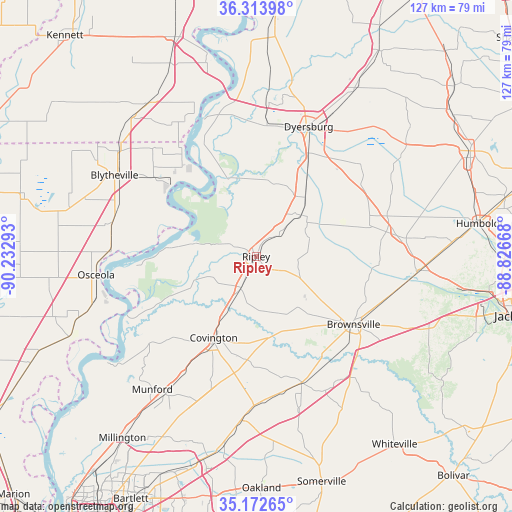
Ripley GPS coordinates[2]
35° 44' 43.296" North, 89° 31' 47.28" West
| Map corner | latitude | longitude |
|---|---|---|
| Upper-left | 36.31398°, | -90.23293° |
| Center: | 35.74536°, | -89.5298° |
| Lower-right: | 35.17265°, | -88.82668° |
| Map W x H: | 126.9×126.9 km | = 78.9×78.9mi |
| max Lat: | 71.29058° ⇑71.6% North |
| Ripley: | 35.74536° |
| min Lat: | ⇓28.4% South 19.06759° |
| min Long | Ripley | max Long |
| -171.73463° | -89.5298° | -66.98998° |
| W 42.4%⇐ | ⇒57.6% E |
Elevation
Elevation of Ripley is 140 m = 459 ft, and this is 154.8 m = 508 ft below average elevation for this country.
| Max E: |
3189 m = 10463 ft | 62.7% |
| Avg. | 294.8 m = 967 ft | |
| Ripley | 140 m = 459 ft | |
Min E: |
-60 m = -197 ft | 37.3% |
See also: United States elevation on elevation.city.
Geographical zone
Ripley is located in North temperate zone (between Tropic of Cancer and the Arctic Circle). Distance of this Northern Tropic circle is 1368.6 km =850.4 mi to South.| Distance of | km | miles | from Ripley |
|---|---|---|---|
| North Pole | 6032.6 | 3748.5 | to North |
| Arctic Circle | 3426.7 | 2129.3 | to North |
| Tropic Cancer | 1368.6 | 850.4 | to South |
| Equator | 3974.5 | 2469.6 | to South |


Nearby cities:
15 places around Ripley: (largest is in red/bold)
• Alamo
37.5 km =23.3 mi,  83°
83°
• Bells
40.1 km =24.9 mi,  95°
95°
• Brighton
34 km =21.1 mi,  211°
211°
• Brownsville
29.4 km =18.3 mi,  124°
124°
• Central
6.5 km =4 mi,  354°
354°
• Covington
22.7 km =14.1 mi, 207°
• Dyersburg
34.7 km =21.6 mi,  21°
21°
• Friendship
31.4 km =19.5 mi,  54°
54°
• Gates
15.2 km =9.4 mi, 47°
• Halls
18.8 km =11.7 mi,  39°
39°
• Henning
9 km =5.6 mi, 206°
• Luxora
36 km =22.4 mi,  271°
271°
• Mason
37.1 km =23.1 mi,  180°
180°
• Maury City
28.5 km =17.7 mi,  74°
74°
• Osceola
39.9 km =24.8 mi,  263°
263°
Sources, notices
• [Note1] Compared only with cities in United States existing in our database
• [Src1] Map data: © OpenStreetMap contributors (CC-BY-SA)
• [Src2] Other city data from geonames.org with taken over terms of usage.
• [Src3] Geographical zone / Annual Mean Temperature by Robert A. Rohde @ Wikipedia
