Sewanee geodata
Sewanee (Tennessee) is a populated place; located in United States in America/Chicago (GMT-5) time zone. With population of 2,311 people, there are 11057 cities with bigger population in this country. Compared to other cities in United States, 74.3% of cities are located further ↑North; 53.1% of cities are located further ←West and 89.5% of cities have lower elevation than Sewanee. Note1


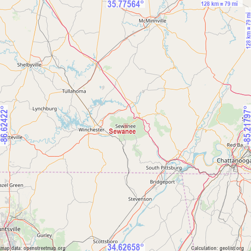
Sewanee GPS coordinates[2]
35° 12' 11.304" North, 85° 55' 15.924" West
| Map corner | latitude | longitude |
|---|---|---|
| Upper-left | 35.77564°, | -86.62422° |
| Center: | 35.20314°, | -85.92109° |
| Lower-right: | 34.62658°, | -85.21797° |
| Map W x H: | 127.8×127.8 km | = 79.4×79.4mi |
| max Lat: | 71.29058° ⇑74.3% North |
| Sewanee: | 35.20314° |
| min Lat: | ⇓25.7% South 19.06759° |
| min Long | Sewanee | max Long |
| -171.73463° | -85.92109° | -66.98998° |
| W 53.1%⇐ | ⇒46.9% E |
Elevation
Elevation of Sewanee is 591 m = 1939 ft, and this is 296.2 m = 972 ft above average elevation for this country.
| Max E: |
3189 m = 10463 ft | 10.5% |
| Sewanee | 591 m 1939 ft | |
| Avg. | 294.8 m = 967 ft | |
Min E: |
-60 m = -197 ft | 89.5% |
See also: United States elevation on elevation.city.
Geographical zone
Sewanee is located in North temperate zone (between Tropic of Cancer and the Arctic Circle). Distance of this Northern Tropic circle is 1308.3 km =812.9 mi to South.| Distance of | km | miles | from Sewanee |
|---|---|---|---|
| North Pole | 6092.8 | 3785.9 | to North |
| Arctic Circle | 3487 | 2166.7 | to North |
| Tropic Cancer | 1308.3 | 812.9 | to South |
| Equator | 3914.2 | 2432.2 | to South |


Nearby cities:
15 places around Sewanee: (largest is in red/bold)
• Altamont
30.9 km =19.2 mi,  35°
35°
• Bridgeport
34.1 km =21.2 mi,  146°
146°
• Coalmont
24.7 km =15.3 mi,  52°
52°
• Cowan
9.2 km =5.7 mi,  242°
242°
• Decherd
14.4 km =8.9 mi,  272°
272°
• Estill Springs
20.2 km =12.6 mi,  291°
291°
• Gruetli-Laager
33.3 km =20.7 mi,  55°
55°
• Jasper
30.4 km =18.9 mi,  118°
118°
• Kimball
28.5 km =17.7 mi,  127°
127°
• Monteagle
8.5 km =5.3 mi, 60°
• New Hope
32.5 km =20.2 mi, 132°
• South Pittsburg
29 km =18 mi,  137°
137°
• Tracy City
18 km =11.2 mi,  69°
69°
• Tullahoma
31.6 km =19.6 mi,  304°
304°
• Winchester
17.5 km =10.9 mi,  263°
263°
Sources, notices
• [Note1] Compared only with cities in United States existing in our database
• [Src1] Map data: © OpenStreetMap contributors (CC-BY-SA)
• [Src2] Other city data from geonames.org with taken over terms of usage.
• [Src3] Geographical zone / Annual Mean Temperature by Robert A. Rohde @ Wikipedia
