Jasper geodata
Jasper (Tennessee) is a seat of a second-order administrative division; located in United States in America/Chicago (GMT-5) time zone. With population of 3,312 people, there are 9128 cities with bigger population in this country. Compared to other cities in United States, 75% of cities are located further ↑North; 54.1% of cities are located further ←West and 52.5% of cities have higher elevation than Jasper. Note1


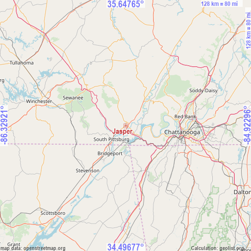
Jasper GPS coordinates[2]
35° 4' 27.264" North, 85° 37' 33.888" West
| Map corner | latitude | longitude |
|---|---|---|
| Upper-left | 35.64765°, | -86.32921° |
| Center: | 35.07424°, | -85.62608° |
| Lower-right: | 34.49677°, | -84.92296° |
| Map W x H: | 128×128 km | = 79.5×79.5mi |
| max Lat: | 71.29058° ⇑75% North |
| Jasper: | 35.07424° |
| min Lat: | ⇓25% South 19.06759° |
| min Long | Jasper | max Long |
| -171.73463° | -85.62608° | -66.98998° |
| W 54.1%⇐ | ⇒45.9% E |
Elevation
Elevation of Jasper is 189 m = 620 ft, and this is 105.8 m = 347 ft below average elevation for this country.
| Max E: |
3189 m = 10463 ft | 52.5% |
| Avg. | 294.8 m = 967 ft | |
| Jasper | 189 m = 620 ft | |
Min E: |
-60 m = -197 ft | 47.5% |
See also: United States elevation on elevation.city.
Geographical zone
Jasper is located in North temperate zone (between Tropic of Cancer and the Arctic Circle). Distance of this Northern Tropic circle is 1294 km =804.1 mi to South.| Distance of | km | miles | from Jasper |
|---|---|---|---|
| North Pole | 6107.2 | 3794.8 | to North |
| Arctic Circle | 3501.3 | 2175.6 | to North |
| Tropic Cancer | 1294 | 804.1 | to South |
| Equator | 3899.9 | 2423.3 | to South |


Nearby cities:
15 places around Jasper: (largest is in red/bold)
• Bridgeport
16.2 km =10.1 mi,  209°
209°
• Chattanooga
29 km =18 mi,  96°
96°
• Chattanooga Valley
29.2 km =18.1 mi,  122°
122°
• Kimball
5.1 km =3.2 mi,  234°
234°
• Lone Oak
27.7 km =17.2 mi,  59°
59°
• Lookout Mountain
26.7 km =16.6 mi,  109°
109°
• Lookout Mountain
26.7 km =16.6 mi, 113°
• Monteagle
26.8 km =16.7 mi,  313°
313°
• New Hope
8.2 km =5.1 mi,  200°
200°
• Powells Crossroads
18.1 km =11.2 mi,  44°
44°
• Signal Mountain
26.2 km =16.3 mi,  78°
78°
• South Pittsburg
9.9 km =6.2 mi, 225°
• Tracy City
23 km =14.3 mi,  334°
334°
• Trenton
24.9 km =15.5 mi,  154°
154°
• Whitwell
17.2 km =10.7 mi,  34°
34°
Sources, notices
• [Note1] Compared only with cities in United States existing in our database
• [Src1] Map data: © OpenStreetMap contributors (CC-BY-SA)
• [Src2] Other city data from geonames.org with taken over terms of usage.
• [Src3] Geographical zone / Annual Mean Temperature by Robert A. Rohde @ Wikipedia
