Alief geodata
Alief (Texas) is a populated place; located in United States in America/Chicago (GMT-5) time zone. With population of 98,725 people, there are 356 cities with bigger population in this country. Compared to other cities in United States, 94.1% of cities are located further ↑North; 72.6% of cities are located further →East and 85.4% of cities have higher elevation than Alief. Note1


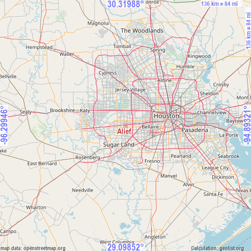
Alief GPS coordinates[2]
29° 42' 39.816" North, 95° 35' 46.788" West
| Map corner | latitude | longitude |
|---|---|---|
| Upper-left | 30.31988°, | -96.29946° |
| Center: | 29.71106°, | -95.59633° |
| Lower-right: | 29.09852°, | -94.89321° |
| Map W x H: | 135.8×135.8 km | = 84.4×84.4mi |
| max Lat: | 71.29058° ⇑94.1% North |
| Alief: | 29.71106° |
| min Lat: | ⇓5.9% South 19.06759° |
| min Long | Alief | max Long |
| -171.73463° | -95.59633° | -66.98998° |
| W 27.4%⇐ | ⇒72.6% E |
Elevation
Elevation of Alief is 27 m = 89 ft, and this is 267.8 m = 879 ft below average elevation for this country.
| Max E: |
3189 m = 10463 ft | 85.4% |
| Avg. | 294.8 m = 967 ft | |
| Alief | 27 m = 89 ft | |
Min E: |
-60 m = -197 ft | 14.6% |
See also: Alief elevation on elevation.city.
Geographical zone
Alief is located in North temperate zone (between Tropic of Cancer and the Arctic Circle). Distance of this Northern Tropic circle is 697.6 km =433.5 mi to South.| Distance of | km | miles | from Alief |
|---|---|---|---|
| North Pole | 6703.5 | 4165.4 | to North |
| Arctic Circle | 4097.6 | 2546.1 | to North |
| Tropic Cancer | 697.6 | 433.5 | to South |
| Equator | 3303.6 | 2052.8 | to South |


Nearby cities:
15 places around Alief: (largest is in red/bold)
• Bellaire
13.3 km =8.3 mi,  92°
92°
• Bunker Hill Village
9 km =5.6 mi,  45°
45°
• Fifth Street
13.3 km =8.3 mi,  160°
160°
• Four Corners
7.6 km =4.7 mi,  231°
231°
• Hedwig Village
10.6 km =6.6 mi, 45°
• Hilshire Village
13.6 km =8.5 mi, 49°
• Hunters Creek Village
11.8 km =7.3 mi,  55°
55°
• Meadows Place
6.7 km =4.2 mi,  173°
173°
• Mission Bend
6.9 km =4.3 mi,  253°
253°
• Missouri City
11.7 km =7.3 mi,  151°
151°
• Piney Point Village
9.4 km =5.8 mi, 54°
• Southside Place
15.4 km =9.6 mi, 92°
• Spring Valley
12.5 km =7.8 mi, 45°
• Stafford
11.2 km =7 mi, 160°
• Sugar Land
10.8 km =6.7 mi,  200°
200°
Sources, notices
• [Note1] Compared only with cities in United States existing in our database
• [Src1] Map data: © OpenStreetMap contributors (CC-BY-SA)
• [Src2] Other city data from geonames.org with taken over terms of usage.
• [Src3] Geographical zone / Annual Mean Temperature by Robert A. Rohde @ Wikipedia
