Stafford geodata
Stafford (Texas) is a populated place; located in United States in America/Chicago (GMT-5) time zone. With population of 18,459 people, there are 2719 cities with bigger population in this country. Compared to other cities in United States, 94.3% of cities are located further ↑North; 72.5% of cities are located further →East and 85.1% of cities have higher elevation than Stafford. Note1


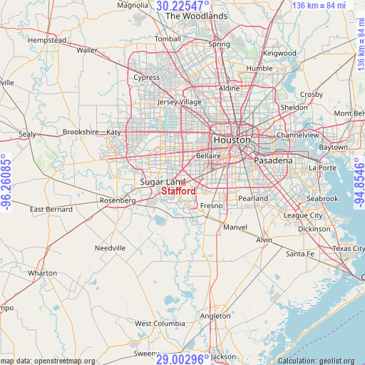
Stafford GPS coordinates[2]
29° 36' 57.852" North, 95° 33' 27.792" West
| Map corner | latitude | longitude |
|---|---|---|
| Upper-left | 30.22547°, | -96.26085° |
| Center: | 29.61607°, | -95.55772° |
| Lower-right: | 29.00296°, | -94.8546° |
| Map W x H: | 135.9×135.9 km | = 84.4×84.4mi |
| max Lat: | 71.29058° ⇑94.3% North |
| Stafford: | 29.61607° |
| min Lat: | ⇓5.7% South 19.06759° |
| min Long | Stafford | max Long |
| -171.73463° | -95.55772° | -66.98998° |
| W 27.5%⇐ | ⇒72.5% E |
Elevation
Elevation of Stafford is 28 m = 92 ft, and this is 266.8 m = 875 ft below average elevation for this country.
| Max E: |
3189 m = 10463 ft | 85.1% |
| Avg. | 294.8 m = 967 ft | |
| Stafford | 28 m = 92 ft | |
Min E: |
-60 m = -197 ft | 14.9% |
See also: United States elevation on elevation.city.
Geographical zone
Stafford is located in North temperate zone (between Tropic of Cancer and the Arctic Circle). Distance of this Northern Tropic circle is 687.1 km =426.9 mi to South.| Distance of | km | miles | from Stafford |
|---|---|---|---|
| North Pole | 6714.1 | 4171.9 | to North |
| Arctic Circle | 4108.2 | 2552.7 | to North |
| Tropic Cancer | 687.1 | 426.9 | to South |
| Equator | 3293 | 2046.2 | to South |


Nearby cities:
15 places around Stafford: (largest is in red/bold)
• Alief
11.2 km =7 mi,  340°
340°
• Arcola
16 km =9.9 mi,  146°
146°
• Bellaire
13.8 km =8.6 mi,  43°
43°
• Fifth Street
2.1 km =1.3 mi,  162°
162°
• Four Corners
11.3 km =7 mi,  301°
301°
• Fresno
13.7 km =8.5 mi,  128°
128°
• Greatwood
13.3 km =8.3 mi,  238°
238°
• Meadows Place
4.9 km =3 mi,  323°
323°
• Mission Bend
13.5 km =8.4 mi,  309°
309°
• Missouri City
2 km =1.2 mi,  81°
81°
• New Territory
12.1 km =7.5 mi,  258°
258°
• Piney Point Village
16.5 km =10.3 mi,  13°
13°
• Sienna Plantation
15.2 km =9.4 mi, 161°
• Southside Place
15.4 km =9.6 mi,  49°
49°
• Sugar Land
7.5 km =4.7 mi,  273°
273°
Sources, notices
• [Note1] Compared only with cities in United States existing in our database
• [Src1] Map data: © OpenStreetMap contributors (CC-BY-SA)
• [Src2] Other city data from geonames.org with taken over terms of usage.
• [Src3] Geographical zone / Annual Mean Temperature by Robert A. Rohde @ Wikipedia
