Beaumont geodata
Beaumont (Texas) is a seat of a second-order administrative division; located in United States in America/Chicago (GMT-5) time zone. With population of 118,129 people, there are 267 cities with bigger population in this country. Compared to other cities in United States, 93.1% of cities are located further ↑North; 68.8% of cities are located further →East and 92.1% of cities have higher elevation than Beaumont. Note1


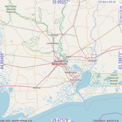
Beaumont GPS coordinates[2]
30° 5' 9.78" North, 94° 6' 6.66" West
| Map corner | latitude | longitude |
|---|---|---|
| Upper-left | 30.69257°, | -94.80498° |
| Center: | 30.08605°, | -94.10185° |
| Lower-right: | 29.47579°, | -93.39873° |
| Map W x H: | 135.3×135.3 km | = 84.1×84.1mi |
| max Lat: | 71.29058° ⇑93.1% North |
| Beaumont: | 30.08605° |
| min Lat: | ⇓6.9% South 19.06759° |
| min Long | Beaumont | max Long |
| -171.73463° | -94.10185° | -66.98998° |
| W 31.2%⇐ | ⇒68.8% E |
Elevation
Elevation of Beaumont is 12 m = 39 ft, and this is 282.8 m = 928 ft below average elevation for this country.
| Max E: |
3189 m = 10463 ft | 92.1% |
| Avg. | 294.8 m = 967 ft | |
| Beaumont | 12 m = 39 ft | |
Min E: |
-60 m = -197 ft | 7.9% |
See also: Beaumont elevation on elevation.city.
Geographical zone
Beaumont is located in North temperate zone (between Tropic of Cancer and the Arctic Circle). Distance of this Northern Tropic circle is 739.3 km =459.4 mi to South.| Distance of | km | miles | from Beaumont |
|---|---|---|---|
| North Pole | 6661.8 | 4139.4 | to North |
| Arctic Circle | 4055.9 | 2520.2 | to North |
| Tropic Cancer | 739.3 | 459.4 | to South |
| Equator | 3345.3 | 2078.7 | to South |


Nearby cities:
15 places around Beaumont: (largest is in red/bold)
• Bevil Oaks
17.6 km =10.9 mi,  293°
293°
• Bridge City
25.7 km =16 mi,  106°
106°
• Central Gardens
13.1 km =8.1 mi,  139°
139°
• China
22.9 km =14.2 mi,  259°
259°
• Fannett
22.8 km =14.2 mi,  218°
218°
• Groves
23.5 km =14.6 mi,  130°
130°
• Lumberton
22.1 km =13.7 mi,  334°
334°
• Mauriceville
26.1 km =16.2 mi,  60°
60°
• Nederland
16.3 km =10.1 mi, 139°
• Pine Forest
12.4 km =7.7 mi,  31°
31°
• Pinewood Estates
22.9 km =14.2 mi, 292°
• Port Arthur
27.1 km =16.8 mi,  145°
145°
• Port Neches
17.4 km =10.8 mi, 127°
• Rose City
5.2 km =3.2 mi,  68°
68°
• Vidor
9.7 km =6 mi, 58°
Sources, notices
• [Note1] Compared only with cities in United States existing in our database
• [Src1] Map data: © OpenStreetMap contributors (CC-BY-SA)
• [Src2] Other city data from geonames.org with taken over terms of usage.
• [Src3] Geographical zone / Annual Mean Temperature by Robert A. Rohde @ Wikipedia
