Pine Forest geodata
Pine Forest (Texas) is a populated place; located in United States in America/Chicago (GMT-5) time zone. With population of 506 people, there are 20811 cities with bigger population in this country. Compared to other cities in United States, 92.8% of cities are located further ↑North; 68.7% of cities are located further →East and 93% of cities have higher elevation than Pine Forest. Note1


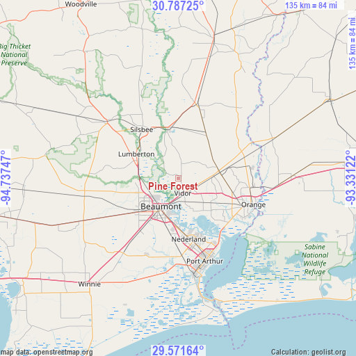
Pine Forest GPS coordinates[2]
30° 10' 52.752" North, 94° 2' 3.624" West
| Map corner | latitude | longitude |
|---|---|---|
| Upper-left | 30.78725°, | -94.73747° |
| Center: | 30.18132°, | -94.03434° |
| Lower-right: | 29.57164°, | -93.33122° |
| Map W x H: | 135.2×135.2 km | = 84×84mi |
| max Lat: | 71.29058° ⇑92.8% North |
| Pine Forest: | 30.18132° |
| min Lat: | ⇓7.2% South 19.06759° |
| min Long | Pine Forest | max Long |
| -171.73463° | -94.03434° | -66.98998° |
| W 31.3%⇐ | ⇒68.7% E |
Elevation
Elevation of Pine Forest is 11 m = 36 ft, and this is 283.8 m = 931 ft below average elevation for this country.
| Max E: |
3189 m = 10463 ft | 93% |
| Avg. | 294.8 m = 967 ft | |
| Pine Forest | 11 m = 36 ft | |
Min E: |
-60 m = -197 ft | 7% |
See also: United States elevation on elevation.city.
Geographical zone
Pine Forest is located in North temperate zone (between Tropic of Cancer and the Arctic Circle). Distance of this Northern Tropic circle is 749.9 km =466 mi to South.| Distance of | km | miles | from Pine Forest |
|---|---|---|---|
| North Pole | 6651.2 | 4132.9 | to North |
| Arctic Circle | 4045.3 | 2513.6 | to North |
| Tropic Cancer | 749.9 | 466 | to South |
| Equator | 3355.8 | 2085.2 | to South |


Nearby cities:
15 places around Pine Forest: (largest is in red/bold)
• Beaumont
12.4 km =7.7 mi,  211°
211°
• Bevil Oaks
22.9 km =14.2 mi,  261°
261°
• Bridge City
25.5 km =15.8 mi,  134°
134°
• Central Gardens
20.8 km =12.9 mi,  174°
174°
• Evadale
19.7 km =12.2 mi,  349°
349°
• Groves
28.3 km =17.6 mi,  156°
156°
• Lumberton
18.4 km =11.4 mi,  300°
300°
• Mauriceville
16.3 km =10.1 mi,  81°
81°
• Nederland
23.4 km =14.5 mi, 170°
• Pinehurst
26.3 km =16.3 mi,  108°
108°
• Pinewood Estates
27.7 km =17.2 mi,  266°
266°
• Port Neches
22.4 km =13.9 mi, 160°
• Rose City
8.9 km =5.5 mi,  190°
190°
• Silsbee
23.2 km =14.4 mi,  323°
323°
• Vidor
5.8 km =3.6 mi, 161°
Sources, notices
• [Note1] Compared only with cities in United States existing in our database
• [Src1] Map data: © OpenStreetMap contributors (CC-BY-SA)
• [Src2] Other city data from geonames.org with taken over terms of usage.
• [Src3] Geographical zone / Annual Mean Temperature by Robert A. Rohde @ Wikipedia
