Cibolo geodata
Cibolo (Texas) is a populated place; located in United States in America/Chicago (GMT-5) time zone. With population of 26,637 people, there are 1881 cities with bigger population in this country. Compared to other cities in United States, 94.5% of cities are located further ↑North; 78.9% of cities are located further →East and 54.7% of cities have lower elevation than Cibolo. Note1


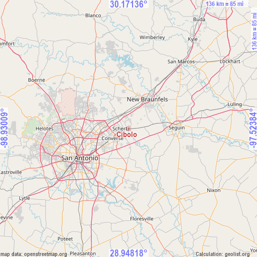
Cibolo GPS coordinates[2]
29° 33' 41.832" North, 98° 13' 37.056" West
| Map corner | latitude | longitude |
|---|---|---|
| Upper-left | 30.17136°, | -98.93009° |
| Center: | 29.56162°, | -98.22696° |
| Lower-right: | 28.94818°, | -97.52384° |
| Map W x H: | 136×136 km | = 84.5×84.5mi |
| max Lat: | 71.29058° ⇑94.5% North |
| Cibolo: | 29.56162° |
| min Lat: | ⇓5.5% South 19.06759° |
| min Long | Cibolo | max Long |
| -171.73463° | -98.22696° | -66.98998° |
| W 21.1%⇐ | ⇒78.9% E |
Elevation
Elevation of Cibolo is 217 m = 712 ft, and this is 77.8 m = 255 ft below average elevation for this country.
| Max E: |
3189 m = 10463 ft | 45.3% |
| Avg. | 294.8 m = 967 ft | |
| Cibolo | 217 m = 712 ft | |
Min E: |
-60 m = -197 ft | 54.7% |
See also: United States elevation on elevation.city.
Geographical zone
Cibolo is located in North temperate zone (between Tropic of Cancer and the Arctic Circle). Distance of this Northern Tropic circle is 681 km =423.2 mi to South.| Distance of | km | miles | from Cibolo |
|---|---|---|---|
| North Pole | 6720.1 | 4175.7 | to North |
| Arctic Circle | 4114.2 | 2556.4 | to North |
| Tropic Cancer | 681 | 423.2 | to South |
| Equator | 3286.9 | 2042.4 | to South |


Nearby cities:
15 places around Cibolo: (largest is in red/bold)
• Converse
9.9 km =6.2 mi,  240°
240°
• Garden Ridge
11.1 km =6.9 mi,  317°
317°
• Kirby
18.8 km =11.7 mi,  234°
234°
• Live Oak
10.6 km =6.6 mi,  272°
272°
• Marion
8.5 km =5.3 mi,  82°
82°
• McQueeney
19 km =11.8 mi, 79°
• New Berlin
16.3 km =10.1 mi,  131°
131°
• New Braunfels
18.6 km =11.6 mi,  32°
32°
• Northcliff
6.6 km =4.1 mi,  1°
1°
• Saint Hedwig
16.6 km =10.3 mi,  170°
170°
• Santa Clara
11.6 km =7.2 mi,  118°
118°
• Schertz
4.3 km =2.7 mi,  255°
255°
• Selma
8 km =5 mi,  288°
288°
• Universal City
6.4 km =4 mi, 256°
• Windcrest
15.7 km =9.8 mi,  250°
250°
Sources, notices
• [Note1] Compared only with cities in United States existing in our database
• [Src1] Map data: © OpenStreetMap contributors (CC-BY-SA)
• [Src2] Other city data from geonames.org with taken over terms of usage.
• [Src3] Geographical zone / Annual Mean Temperature by Robert A. Rohde @ Wikipedia
