Garden Ridge geodata
Garden Ridge (Texas) is a populated place; located in United States in America/Chicago (GMT-5) time zone. With population of 3,850 people, there are 8393 cities with bigger population in this country. Compared to other cities in United States, 94.3% of cities are located further ↑North; 79% of cities are located further →East and 68.5% of cities have lower elevation than Garden Ridge. Note1


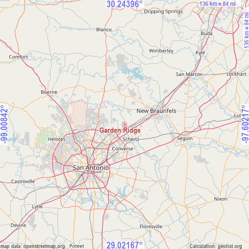
Garden Ridge GPS coordinates[2]
29° 38' 4.812" North, 98° 18' 19.044" West
| Map corner | latitude | longitude |
|---|---|---|
| Upper-left | 30.24396°, | -99.00842° |
| Center: | 29.63467°, | -98.30529° |
| Lower-right: | 29.02167°, | -97.60217° |
| Map W x H: | 135.9×135.9 km | = 84.4×84.4mi |
| max Lat: | 71.29058° ⇑94.3% North |
| Garden Ridge: | 29.63467° |
| min Lat: | ⇓5.7% South 19.06759° |
| min Long | Garden Ridge | max Long |
| -171.73463° | -98.30529° | -66.98998° |
| W 21%⇐ | ⇒79% E |
Elevation
Elevation of Garden Ridge is 278 m = 912 ft, and this is 16.8 m = 55 ft below average elevation for this country.
| Max E: |
3189 m = 10463 ft | 31.5% |
| Avg. | 294.8 m = 967 ft | |
| Garden Ridge | 278 m = 912 ft | |
Min E: |
-60 m = -197 ft | 68.5% |
See also: United States elevation on elevation.city.
Geographical zone
Garden Ridge is located in North temperate zone (between Tropic of Cancer and the Arctic Circle). Distance of this Northern Tropic circle is 689.1 km =428.2 mi to South.| Distance of | km | miles | from Garden Ridge |
|---|---|---|---|
| North Pole | 6712 | 4170.6 | to North |
| Arctic Circle | 4106.1 | 2551.4 | to North |
| Tropic Cancer | 689.1 | 428.2 | to South |
| Equator | 3295.1 | 2047.5 | to South |


Nearby cities:
15 places around Garden Ridge: (largest is in red/bold)
• Bulverde
18.7 km =11.6 mi,  310°
310°
• Cibolo
11.1 km =6.9 mi,  137°
137°
• Converse
13 km =8.1 mi,  184°
184°
• Hill Country Village
18.9 km =11.7 mi,  252°
252°
• Hollywood Park
18 km =11.2 mi,  257°
257°
• Kirby
20.6 km =12.8 mi,  202°
202°
• Live Oak
8.3 km =5.2 mi, 201°
• Marion
17.4 km =10.8 mi,  113°
113°
• New Braunfels
19.1 km =11.9 mi,  66°
66°
• Northcliff
7.9 km =4.9 mi,  100°
100°
• Schertz
9.8 km =6.1 mi,  159°
159°
• Selma
5.6 km =3.5 mi, 180°
• Timberwood Park
18.5 km =11.5 mi,  295°
295°
• Universal City
9.7 km =6 mi,  171°
171°
• Windcrest
15.1 km =9.4 mi,  208°
208°
Sources, notices
• [Note1] Compared only with cities in United States existing in our database
• [Src1] Map data: © OpenStreetMap contributors (CC-BY-SA)
• [Src2] Other city data from geonames.org with taken over terms of usage.
• [Src3] Geographical zone / Annual Mean Temperature by Robert A. Rohde @ Wikipedia
