Double Oak geodata
Double Oak (Texas) is a populated place; located in United States in America/Chicago (GMT-5) time zone. With population of 3,078 people, there are 9501 cities with bigger population in this country. Compared to other cities in United States, 84.9% of cities are located further ↑North; 76% of cities are located further →East and 51.5% of cities have lower elevation than Double Oak. Note1


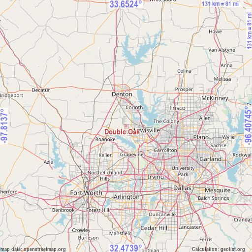
Double Oak GPS coordinates[2]
33° 3' 54.432" North, 97° 6' 38.052" West
| Map corner | latitude | longitude |
|---|---|---|
| Upper-left | 33.6524°, | -97.8137° |
| Center: | 33.06512°, | -97.11057° |
| Lower-right: | 32.4739°, | -96.40745° |
| Map W x H: | 131×131 km | = 81.4×81.4mi |
| max Lat: | 71.29058° ⇑84.9% North |
| Double Oak: | 33.06512° |
| min Lat: | ⇓15.1% South 19.06759° |
| min Long | Double Oak | max Long |
| -171.73463° | -97.11057° | -66.98998° |
| W 24%⇐ | ⇒76% E |
Elevation
Elevation of Double Oak is 204 m = 669 ft, and this is 90.8 m = 298 ft below average elevation for this country.
| Max E: |
3189 m = 10463 ft | 48.5% |
| Avg. | 294.8 m = 967 ft | |
| Double Oak | 204 m = 669 ft | |
Min E: |
-60 m = -197 ft | 51.5% |
See also: United States elevation on elevation.city.
Geographical zone
Double Oak is located in North temperate zone (between Tropic of Cancer and the Arctic Circle). Distance of this Northern Tropic circle is 1070.6 km =665.2 mi to South.| Distance of | km | miles | from Double Oak |
|---|---|---|---|
| North Pole | 6330.6 | 3933.7 | to North |
| Arctic Circle | 3724.7 | 2314.4 | to North |
| Tropic Cancer | 1070.6 | 665.2 | to South |
| Equator | 3676.5 | 2284.5 | to South |


Nearby cities:
15 places around Double Oak: (largest is in red/bold)
• Argyle
9.2 km =5.7 mi,  312°
312°
• Bartonville
2.2 km =1.4 mi,  294°
294°
• Copper Canyon
3.7 km =2.3 mi,  20°
20°
• Corinth
10.8 km =6.7 mi, 23°
• Flower Mound
5.8 km =3.6 mi,  167°
167°
• Hickory Creek
8.9 km =5.5 mi,  44°
44°
• Highland Village
6.7 km =4.2 mi,  63°
63°
• Lake Dallas
9.9 km =6.2 mi,  52°
52°
• Lantana
3.1 km =1.9 mi,  336°
336°
• Lewisville
11 km =6.8 mi,  100°
100°
• Marshall Creek
10.6 km =6.6 mi,  239°
239°
• Roanoke
12.7 km =7.9 mi, 237°
• Shady Shores
13.4 km =8.3 mi,  34°
34°
• Trophy Club
10.1 km =6.3 mi,  222°
222°
• Westlake
11.4 km =7.1 mi, 223°
Sources, notices
• [Note1] Compared only with cities in United States existing in our database
• [Src1] Map data: © OpenStreetMap contributors (CC-BY-SA)
• [Src2] Other city data from geonames.org with taken over terms of usage.
• [Src3] Geographical zone / Annual Mean Temperature by Robert A. Rohde @ Wikipedia
