Lewisville geodata
Lewisville (Texas) is a populated place; located in United States in America/Chicago (GMT-5) time zone. With population of 104,039 people, there are 332 cities with bigger population in this country. Compared to other cities in United States, 85% of cities are located further ↑North; 75.7% of cities are located further →East and 58.8% of cities have higher elevation than Lewisville. Note1


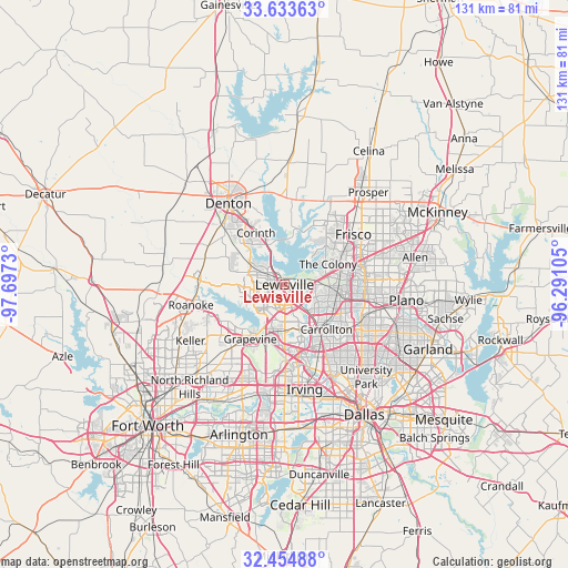
Lewisville GPS coordinates[2]
33° 2' 46.428" North, 96° 59' 39.012" West
| Map corner | latitude | longitude |
|---|---|---|
| Upper-left | 33.63363°, | -97.6973° |
| Center: | 33.04623°, | -96.99417° |
| Lower-right: | 32.45488°, | -96.29105° |
| Map W x H: | 131.1×131.1 km | = 81.5×81.5mi |
| max Lat: | 71.29058° ⇑85% North |
| Lewisville: | 33.04623° |
| min Lat: | ⇓15% South 19.06759° |
| min Long | Lewisville | max Long |
| -171.73463° | -96.99417° | -66.98998° |
| W 24.3%⇐ | ⇒75.7% E |
Elevation
Elevation of Lewisville is 161 m = 528 ft, and this is 133.8 m = 439 ft below average elevation for this country.
| Max E: |
3189 m = 10463 ft | 58.8% |
| Avg. | 294.8 m = 967 ft | |
| Lewisville | 161 m = 528 ft | |
Min E: |
-60 m = -197 ft | 41.2% |
See also: Lewisville elevation on elevation.city.
Geographical zone
Lewisville is located in North temperate zone (between Tropic of Cancer and the Arctic Circle). Distance of this Northern Tropic circle is 1068.5 km =663.9 mi to South.| Distance of | km | miles | from Lewisville |
|---|---|---|---|
| North Pole | 6332.7 | 3935 | to North |
| Arctic Circle | 3726.8 | 2315.7 | to North |
| Tropic Cancer | 1068.5 | 663.9 | to South |
| Equator | 3674.4 | 2283.2 | to South |


Nearby cities:
15 places around Lewisville: (largest is in red/bold)
• Bartonville
13.2 km =8.2 mi,  283°
283°
• Coppell
10.4 km =6.5 mi,  190°
190°
• Copper Canyon
11 km =6.8 mi,  300°
300°
• Corinth
13.7 km =8.5 mi,  331°
331°
• Double Oak
11 km =6.8 mi, 280°
• Flower Mound
10.2 km =6.3 mi,  249°
249°
• Hackberry
13.8 km =8.6 mi,  31°
31°
• Hickory Creek
9.6 km =6 mi, 331°
• Highland Village
7 km =4.3 mi,  315°
315°
• Lake Dallas
8.6 km =5.3 mi,  340°
340°
• Lakewood Village
11 km =6.8 mi,  12°
12°
• Lantana
13.1 km =8.1 mi,  292°
292°
• Little Elm
14 km =8.7 mi,  22°
22°
• Shady Shores
13.6 km =8.5 mi,  346°
346°
• The Colony
11.1 km =6.9 mi,  64°
64°
Sources, notices
• [Note1] Compared only with cities in United States existing in our database
• [Src1] Map data: © OpenStreetMap contributors (CC-BY-SA)
• [Src2] Other city data from geonames.org with taken over terms of usage.
• [Src3] Geographical zone / Annual Mean Temperature by Robert A. Rohde @ Wikipedia
