Hackberry geodata
Hackberry (Texas) is a populated place; located in United States in America/Chicago (GMT-5) time zone. With population of 1,037 people, there are 16038 cities with bigger population in this country. Compared to other cities in United States, 84.6% of cities are located further ↑North; 75.5% of cities are located further →East and 56.9% of cities have higher elevation than Hackberry. Note1


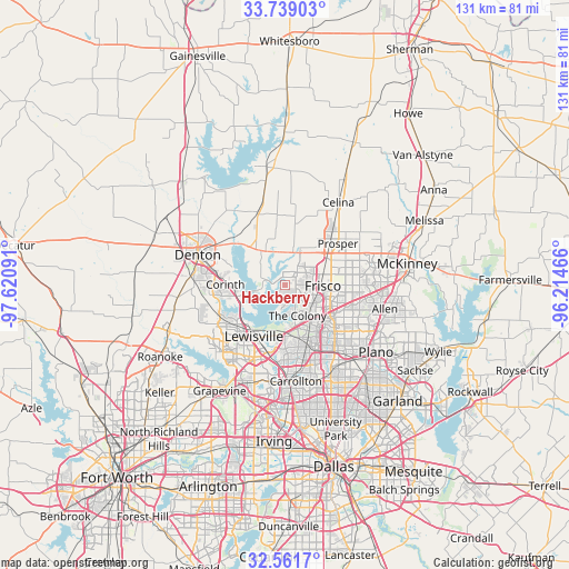
Hackberry GPS coordinates[2]
33° 9' 8.424" North, 96° 55' 4.008" West
| Map corner | latitude | longitude |
|---|---|---|
| Upper-left | 33.73903°, | -97.62091° |
| Center: | 33.15234°, | -96.91778° |
| Lower-right: | 32.5617°, | -96.21466° |
| Map W x H: | 130.9×130.9 km | = 81.3×81.3mi |
| max Lat: | 71.29058° ⇑84.6% North |
| Hackberry: | 33.15234° |
| min Lat: | ⇓15.4% South 19.06759° |
| min Long | Hackberry | max Long |
| -171.73463° | -96.91778° | -66.98998° |
| W 24.5%⇐ | ⇒75.5% E |
Elevation
Elevation of Hackberry is 171 m = 561 ft, and this is 123.8 m = 406 ft below average elevation for this country.
| Max E: |
3189 m = 10463 ft | 56.9% |
| Avg. | 294.8 m = 967 ft | |
| Hackberry | 171 m = 561 ft | |
Min E: |
-60 m = -197 ft | 43.1% |
See also: United States elevation on elevation.city.
Geographical zone
Hackberry is located in North temperate zone (between Tropic of Cancer and the Arctic Circle). Distance of this Northern Tropic circle is 1080.3 km =671.3 mi to South.| Distance of | km | miles | from Hackberry |
|---|---|---|---|
| North Pole | 6320.9 | 3927.6 | to North |
| Arctic Circle | 3715 | 2308.4 | to North |
| Tropic Cancer | 1080.3 | 671.3 | to South |
| Equator | 3686.2 | 2290.5 | to South |


Nearby cities:
15 places around Hackberry: (largest is in red/bold)
• Corinth
13.7 km =8.5 mi,  270°
270°
• Cross Roads
11.7 km =7.3 mi,  318°
318°
• Frisco
8.8 km =5.5 mi,  91°
91°
• Hickory Creek
12.1 km =7.5 mi,  254°
254°
• Lake Dallas
10.7 km =6.6 mi, 249°
• Lakewood Village
4.9 km =3 mi,  257°
257°
• Little Elm
2.2 km =1.4 mi,  301°
301°
• New Hope (historical)
11.3 km =7 mi, 324°
• Oak Point
8.1 km =5 mi, 301°
• Paloma Creek
8.3 km =5.2 mi,  347°
347°
• Paloma Creek South
6.8 km =4.2 mi, 345°
• Providence
9.9 km =6.2 mi,  335°
335°
• Savannah
8.2 km =5.1 mi,  6°
6°
• Shady Shores
10.5 km =6.5 mi,  277°
277°
• The Colony
7.6 km =4.7 mi,  157°
157°
Sources, notices
• [Note1] Compared only with cities in United States existing in our database
• [Src1] Map data: © OpenStreetMap contributors (CC-BY-SA)
• [Src2] Other city data from geonames.org with taken over terms of usage.
• [Src3] Geographical zone / Annual Mean Temperature by Robert A. Rohde @ Wikipedia
