Savannah geodata
Savannah (Texas) is a populated place; located in United States in America/Chicago (GMT-5) time zone. With population of 3,318 people, there are 9113 cities with bigger population in this country. Compared to other cities in United States, 84.2% of cities are located further ↑North; 75.5% of cities are located further →East and 55.5% of cities have higher elevation than Savannah. Note1


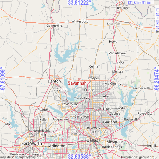
Savannah GPS coordinates[2]
33° 13' 33.708" North, 96° 54' 28.296" West
| Map corner | latitude | longitude |
|---|---|---|
| Upper-left | 33.81222°, | -97.61099° |
| Center: | 33.22603°, | -96.90786° |
| Lower-right: | 32.63588°, | -96.20474° |
| Map W x H: | 130.8×130.8 km | = 81.3×81.3mi |
| max Lat: | 71.29058° ⇑84.2% North |
| Savannah: | 33.22603° |
| min Lat: | ⇓15.8% South 19.06759° |
| min Long | Savannah | max Long |
| -171.73463° | -96.90786° | -66.98998° |
| W 24.5%⇐ | ⇒75.5% E |
Elevation
Elevation of Savannah is 178 m = 584 ft, and this is 116.8 m = 383 ft below average elevation for this country.
| Max E: |
3189 m = 10463 ft | 55.5% |
| Avg. | 294.8 m = 967 ft | |
| Savannah | 178 m = 584 ft | |
Min E: |
-60 m = -197 ft | 44.5% |
See also: United States elevation on elevation.city.
Geographical zone
Savannah is located in North temperate zone (between Tropic of Cancer and the Arctic Circle). Distance of this Northern Tropic circle is 1088.5 km =676.4 mi to South.| Distance of | km | miles | from Savannah |
|---|---|---|---|
| North Pole | 6312.7 | 3922.5 | to North |
| Arctic Circle | 3706.8 | 2303.3 | to North |
| Tropic Cancer | 1088.5 | 676.4 | to South |
| Equator | 3694.4 | 2295.6 | to South |


Nearby cities:
15 places around Savannah: (largest is in red/bold)
• Aubrey
11.3 km =7 mi,  320°
320°
• Cross Roads
8.8 km =5.5 mi,  273°
273°
• Frisco
11.5 km =7.1 mi,  136°
136°
• Hackberry
8.2 km =5.1 mi,  186°
186°
• Krugerville
9.9 km =6.2 mi,  308°
308°
• Lakewood Village
10.9 km =6.8 mi,  211°
211°
• Little Elm
7.6 km =4.7 mi,  201°
201°
• New Hope (historical)
7.6 km =4.7 mi,  277°
277°
• Oak Point
8.8 km =5.5 mi,  242°
242°
• Paloma Creek
2.8 km =1.7 mi, 268°
• Paloma Creek South
3 km =1.9 mi, 237°
• Prosper
10 km =6.2 mi,  83°
83°
• Providence
5.1 km =3.2 mi, 279°
• Shady Shores
13.2 km =8.2 mi, 239°
• The Colony
15.4 km =9.6 mi,  172°
172°
Sources, notices
• [Note1] Compared only with cities in United States existing in our database
• [Src1] Map data: © OpenStreetMap contributors (CC-BY-SA)
• [Src2] Other city data from geonames.org with taken over terms of usage.
• [Src3] Geographical zone / Annual Mean Temperature by Robert A. Rohde @ Wikipedia
