Houston geodata
Houston (Texas) is a seat of a second-order administrative division; located in United States in America/Chicago (GMT-5) time zone. With population of 2,296,224 people, there are 4 cities with bigger population in this country. Compared to other cities in United States, 94% of cities are located further ↑North; 72% of cities are located further →East and 84.4% of cities have higher elevation than Houston. Note1


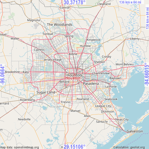
Houston GPS coordinates[2]
29° 45' 47.808" North, 95° 21' 47.772" West
| Map corner | latitude | longitude |
|---|---|---|
| Upper-left | 30.37178°, | -96.0664° |
| Center: | 29.76328°, | -95.36327° |
| Lower-right: | 29.15106°, | -94.66015° |
| Map W x H: | 135.7×135.7 km | = 84.3×84.3mi |
| max Lat: | 71.29058° ⇑94% North |
| Houston: | 29.76328° |
| min Lat: | ⇓6% South 19.06759° |
| min Long | Houston | max Long |
| -171.73463° | -95.36327° | -66.98998° |
| W 28%⇐ | ⇒72% E |
Elevation
Elevation of Houston is 30 m = 98 ft, and this is 264.8 m = 869 ft below average elevation for this country.
| Max E: |
3189 m = 10463 ft | 84.4% |
| Avg. | 294.8 m = 967 ft | |
| Houston | 30 m = 98 ft | |
Min E: |
-60 m = -197 ft | 15.6% |
See also: Houston elevation on elevation.city.
Geographical zone
Houston is located in North temperate zone (between Tropic of Cancer and the Arctic Circle). Distance of this Northern Tropic circle is 703.4 km =437.1 mi to South.| Distance of | km | miles | from Houston |
|---|---|---|---|
| North Pole | 6697.7 | 4161.8 | to North |
| Arctic Circle | 4091.8 | 2542.5 | to North |
| Tropic Cancer | 703.4 | 437.1 | to South |
| Equator | 3309.4 | 2056.4 | to South |


Nearby cities:
15 places around Houston: (largest is in red/bold)
• Aldine
18.9 km =11.7 mi,  355°
355°
• Bellaire
11.2 km =7 mi,  235°
235°
• Bunker Hill Village
16.1 km =10 mi,  271°
271°
• Cloverleaf
18.5 km =11.5 mi,  84°
84°
• Galena Park
13.3 km =8.3 mi,  104°
104°
• Hedwig Village
14.9 km =9.3 mi,  276°
276°
• Hilshire Village
12.5 km =7.8 mi, 284°
• Hunters Creek Village
12.8 km =8 mi, 273°
• Jacinto City
12.5 km =7.8 mi,  87°
87°
• Pasadena
16.9 km =10.5 mi,  118°
118°
• Piney Point Village
14.9 km =9.3 mi, 268°
• South Houston
16.6 km =10.3 mi,  132°
132°
• Southside Place
9.5 km =5.9 mi,  228°
228°
• Spring Valley
13.9 km =8.6 mi, 282°
• West University Place
8.5 km =5.3 mi, 233°
Sources, notices
• [Note1] Compared only with cities in United States existing in our database
• [Src1] Map data: © OpenStreetMap contributors (CC-BY-SA)
• [Src2] Other city data from geonames.org with taken over terms of usage.
• [Src3] Geographical zone / Annual Mean Temperature by Robert A. Rohde @ Wikipedia
