Pasadena geodata
Pasadena (Texas) is a populated place; located in United States in America/Chicago (GMT-5) time zone. With population of 153,784 people, there are 185 cities with bigger population in this country. Compared to other cities in United States, 94.1% of cities are located further ↑North; 71.6% of cities are located further →East and 92.1% of cities have higher elevation than Pasadena. Note1


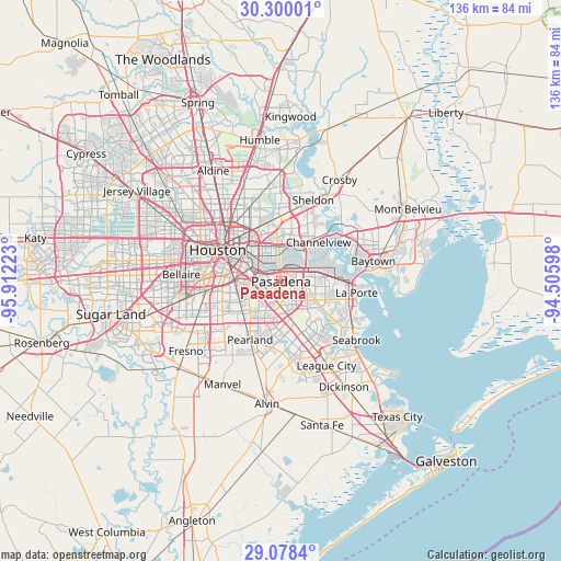
Pasadena GPS coordinates[2]
29° 41' 27.816" North, 95° 12' 32.76" West
| Map corner | latitude | longitude |
|---|---|---|
| Upper-left | 30.30001°, | -95.91223° |
| Center: | 29.69106°, | -95.2091° |
| Lower-right: | 29.0784°, | -94.50598° |
| Map W x H: | 135.8×135.8 km | = 84.4×84.4mi |
| max Lat: | 71.29058° ⇑94.1% North |
| Pasadena: | 29.69106° |
| min Lat: | ⇓5.9% South 19.06759° |
| min Long | Pasadena | max Long |
| -171.73463° | -95.2091° | -66.98998° |
| W 28.4%⇐ | ⇒71.6% E |
Elevation
Elevation of Pasadena is 12 m = 39 ft, and this is 282.8 m = 928 ft below average elevation for this country.
| Max E: |
3189 m = 10463 ft | 92.1% |
| Avg. | 294.8 m = 967 ft | |
| Pasadena | 12 m = 39 ft | |
Min E: |
-60 m = -197 ft | 7.9% |
See also: Pasadena elevation on elevation.city.
Geographical zone
Pasadena is located in North temperate zone (between Tropic of Cancer and the Arctic Circle). Distance of this Northern Tropic circle is 695.4 km =432.1 mi to South.| Distance of | km | miles | from Pasadena |
|---|---|---|---|
| North Pole | 6705.7 | 4166.7 | to North |
| Arctic Circle | 4099.8 | 2547.5 | to North |
| Tropic Cancer | 695.4 | 432.1 | to South |
| Equator | 3301.3 | 2051.3 | to South |


Nearby cities:
15 places around Pasadena: (largest is in red/bold)
• Brookside Village
16.1 km =10 mi,  224°
224°
• Channelview
13.1 km =8.1 mi,  43°
43°
• Cloverleaf
10.3 km =6.4 mi,  20°
20°
• Deer Park
8.4 km =5.2 mi,  79°
79°
• Friendswood
18 km =11.2 mi,  177°
177°
• Galena Park
5.1 km =3.2 mi,  336°
336°
• Highlands
20.5 km =12.7 mi,  46°
46°
• Houston
16.9 km =10.5 mi,  298°
298°
• Jacinto City
8.8 km =5.5 mi, 344°
• La Porte
18.5 km =11.5 mi,  98°
98°
• Nassau Bay
19.9 km =12.4 mi,  144°
144°
• Pearland
16 km =9.9 mi,  207°
207°
• South Houston
4 km =2.5 mi, 219°
• Taylor Lake Village
20 km =12.4 mi,  129°
129°
• Webster
19.2 km =11.9 mi,  152°
152°
Sources, notices
• [Note1] Compared only with cities in United States existing in our database
• [Src1] Map data: © OpenStreetMap contributors (CC-BY-SA)
• [Src2] Other city data from geonames.org with taken over terms of usage.
• [Src3] Geographical zone / Annual Mean Temperature by Robert A. Rohde @ Wikipedia
