League City geodata
League City (Texas) is a populated place; located in United States in America/Chicago (GMT-5) time zone. With population of 98,312 people, there are 361 cities with bigger population in this country. Compared to other cities in United States, 94.6% of cities are located further ↑North; 71.3% of cities are located further →East and 94.8% of cities have higher elevation than League City. Note1


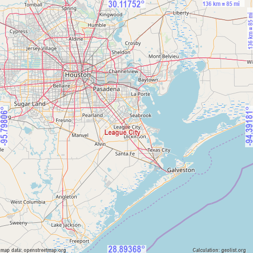
League City GPS coordinates[2]
29° 30' 26.82" North, 95° 5' 41.748" West
| Map corner | latitude | longitude |
|---|---|---|
| Upper-left | 30.11752°, | -95.79806° |
| Center: | 29.50745°, | -95.09493° |
| Lower-right: | 28.89368°, | -94.39181° |
| Map W x H: | 136.1×136.1 km | = 84.6×84.6mi |
| max Lat: | 71.29058° ⇑94.6% North |
| League City: | 29.50745° |
| min Lat: | ⇓5.4% South 19.06759° |
| min Long | League City | max Long |
| -171.73463° | -95.09493° | -66.98998° |
| W 28.7%⇐ | ⇒71.3% E |
Elevation
Elevation of League City is 9 m = 30 ft, and this is 285.8 m = 938 ft below average elevation for this country.
| Max E: |
3189 m = 10463 ft | 94.8% |
| Avg. | 294.8 m = 967 ft | |
| League City | 9 m = 30 ft | |
Min E: |
-60 m = -197 ft | 5.2% |
See also: League City elevation on elevation.city.
Geographical zone
League City is located in North temperate zone (between Tropic of Cancer and the Arctic Circle). Distance of this Northern Tropic circle is 675 km =419.4 mi to South.| Distance of | km | miles | from League City |
|---|---|---|---|
| North Pole | 6726.1 | 4179.4 | to North |
| Arctic Circle | 4120.3 | 2560.2 | to North |
| Tropic Cancer | 675 | 419.4 | to South |
| Equator | 3280.9 | 2038.7 | to South |


Nearby cities:
15 places around League City: (largest is in red/bold)
• Alvin
17.2 km =10.7 mi,  237°
237°
• Bacliff
9.9 km =6.2 mi,  90°
90°
• Clear Lake Shores
7.5 km =4.7 mi,  53°
53°
• Dickinson
6.7 km =4.2 mi,  140°
140°
• El Lago
7.9 km =4.9 mi,  37°
37°
• Friendswood
10.6 km =6.6 mi,  283°
283°
• Kemah
8.2 km =5.1 mi,  61°
61°
• La Porte
19.1 km =11.9 mi,  22°
22°
• Nassau Bay
4.2 km =2.6 mi,  5°
5°
• San Leon
16.9 km =10.5 mi,  99°
99°
• Santa Fe
14.4 km =8.9 mi,  184°
184°
• Seabrook
9.2 km =5.7 mi, 46°
• Shoreacres
15 km =9.3 mi,  33°
33°
• Taylor Lake Village
8.7 km =5.4 mi, 29°
• Webster
4.1 km =2.5 mi,  326°
326°
Sources, notices
• [Note1] Compared only with cities in United States existing in our database
• [Src1] Map data: © OpenStreetMap contributors (CC-BY-SA)
• [Src2] Other city data from geonames.org with taken over terms of usage.
• [Src3] Geographical zone / Annual Mean Temperature by Robert A. Rohde @ Wikipedia
