Friendswood geodata
Friendswood (Texas) is a populated place; located in United States in America/Chicago (GMT-5) time zone. With population of 38,800 people, there are 1248 cities with bigger population in this country. Compared to other cities in United States, 94.6% of cities are located further ↑North; 71.6% of cities are located further →East and 93% of cities have higher elevation than Friendswood. Note1


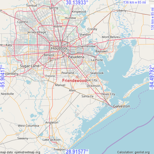
Friendswood GPS coordinates[2]
29° 31' 45.84" North, 95° 12' 3.744" West
| Map corner | latitude | longitude |
|---|---|---|
| Upper-left | 30.13933°, | -95.90417° |
| Center: | 29.5294°, | -95.20104° |
| Lower-right: | 28.91577°, | -94.49792° |
| Map W x H: | 136×136 km | = 84.5×84.5mi |
| max Lat: | 71.29058° ⇑94.6% North |
| Friendswood: | 29.5294° |
| min Lat: | ⇓5.4% South 19.06759° |
| min Long | Friendswood | max Long |
| -171.73463° | -95.20104° | -66.98998° |
| W 28.4%⇐ | ⇒71.6% E |
Elevation
Elevation of Friendswood is 11 m = 36 ft, and this is 283.8 m = 931 ft below average elevation for this country.
| Max E: |
3189 m = 10463 ft | 93% |
| Avg. | 294.8 m = 967 ft | |
| Friendswood | 11 m = 36 ft | |
Min E: |
-60 m = -197 ft | 7% |
See also: United States elevation on elevation.city.
Geographical zone
Friendswood is located in North temperate zone (between Tropic of Cancer and the Arctic Circle). Distance of this Northern Tropic circle is 677.4 km =420.9 mi to South.| Distance of | km | miles | from Friendswood |
|---|---|---|---|
| North Pole | 6723.7 | 4177.9 | to North |
| Arctic Circle | 4117.8 | 2558.7 | to North |
| Tropic Cancer | 677.4 | 420.9 | to South |
| Equator | 3283.4 | 2040.2 | to South |


Nearby cities:
15 places around Friendswood: (largest is in red/bold)
• Alvin
12.5 km =7.8 mi,  199°
199°
• Brookside Village
13.6 km =8.5 mi,  298°
298°
• Clear Lake Shores
16.5 km =10.3 mi,  82°
82°
• Dickinson
16.4 km =10.2 mi,  117°
117°
• El Lago
15.5 km =9.6 mi, 75°
• Hillcrest
16.2 km =10.1 mi, 200°
• Kemah
17.5 km =10.9 mi,  85°
85°
• League City
10.6 km =6.6 mi,  103°
103°
• Manvel
16.9 km =10.5 mi,  243°
243°
• Nassau Bay
10.8 km =6.7 mi, 80°
• Pearland
9.1 km =5.7 mi,  294°
294°
• Seabrook
17.4 km =10.8 mi, 77°
• South Houston
15.2 km =9.4 mi,  347°
347°
• Taylor Lake Village
15.5 km =9.6 mi,  70°
70°
• Webster
8.1 km =5 mi, 83°
Sources, notices
• [Note1] Compared only with cities in United States existing in our database
• [Src1] Map data: © OpenStreetMap contributors (CC-BY-SA)
• [Src2] Other city data from geonames.org with taken over terms of usage.
• [Src3] Geographical zone / Annual Mean Temperature by Robert A. Rohde @ Wikipedia
