Muniz geodata
Muniz (Texas) is a populated place; located in United States in America/Chicago (GMT-5) time zone. With population of 1,370 people, there are 14261 cities with bigger population in this country. Compared to other cities in United States, 98.3% of cities are located further ↑North; 78.7% of cities are located further →East and 84.4% of cities have higher elevation than Muniz. Note1


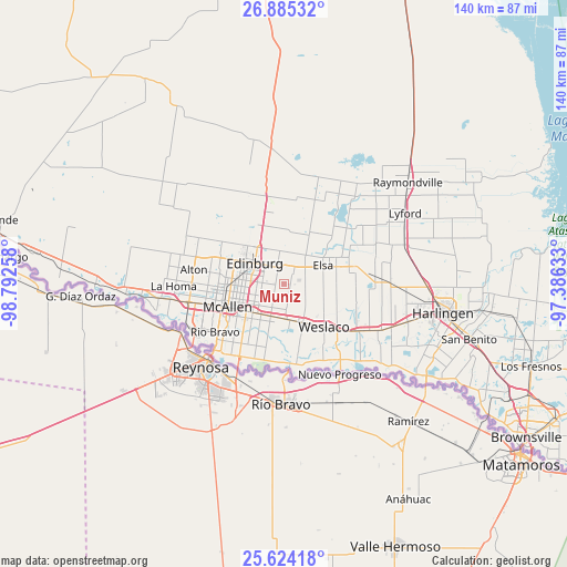
Muniz GPS coordinates[2]
26° 15' 23.256" North, 98° 5' 22.02" West
| Map corner | latitude | longitude |
|---|---|---|
| Upper-left | 26.88532°, | -98.79258° |
| Center: | 26.25646°, | -98.08945° |
| Lower-right: | 25.62418°, | -97.38633° |
| Map W x H: | 140.2×140.2 km | = 87.1×87.1mi |
| max Lat: | 71.29058° ⇑98.3% North |
| Muniz: | 26.25646° |
| min Lat: | ⇓1.7% South 19.06759° |
| min Long | Muniz | max Long |
| -171.73463° | -98.08945° | -66.98998° |
| W 21.3%⇐ | ⇒78.7% E |
Elevation
Elevation of Muniz is 30 m = 98 ft, and this is 264.8 m = 869 ft below average elevation for this country.
| Max E: |
3189 m = 10463 ft | 84.4% |
| Avg. | 294.8 m = 967 ft | |
| Muniz | 30 m = 98 ft | |
Min E: |
-60 m = -197 ft | 15.6% |
See also: United States elevation on elevation.city.
Geographical zone
Muniz is located in North temperate zone (between Tropic of Cancer and the Arctic Circle). Distance of this Northern Tropic circle is 313.5 km =194.8 mi to South.| Distance of | km | miles | from Muniz |
|---|---|---|---|
| North Pole | 7087.6 | 4404 | to North |
| Arctic Circle | 4481.7 | 2784.8 | to North |
| Tropic Cancer | 313.5 | 194.8 | to South |
| Equator | 2919.4 | 1814 | to South |


Nearby cities:
15 places around Muniz: (largest is in red/bold)
• Alamo
8.8 km =5.5 mi,  202°
202°
• César Chávez
5.8 km =3.6 mi,  333°
333°
• Donna
10.3 km =6.4 mi,  158°
158°
• Doolittle
11.1 km =6.9 mi,  345°
345°
• Edinburg
8.9 km =5.5 mi,  304°
304°
• Elsa
10.5 km =6.5 mi,  66°
66°
• La Blanca
6.6 km =4.1 mi,  51°
51°
• Lopezville
7.3 km =4.5 mi,  253°
253°
• Midway North
10.5 km =6.5 mi,  136°
136°
• Murillo Colonia
2.4 km =1.5 mi,  270°
270°
• North Alamo
5.9 km =3.7 mi,  222°
222°
• Nurillo
3.4 km =2.1 mi,  290°
290°
• Olivarez
10.2 km =6.3 mi,  107°
107°
• San Carlos
4.7 km =2.9 mi,  21°
21°
• San Juan
9.9 km =6.2 mi, 221°
Sources, notices
• [Note1] Compared only with cities in United States existing in our database
• [Src1] Map data: © OpenStreetMap contributors (CC-BY-SA)
• [Src2] Other city data from geonames.org with taken over terms of usage.
• [Src3] Geographical zone / Annual Mean Temperature by Robert A. Rohde @ Wikipedia
