Edinburg geodata
Edinburg (Texas) is a seat of a second-order administrative division; located in United States in America/Chicago (GMT-5) time zone. With population of 84,497 people, there are 459 cities with bigger population in this country. Compared to other cities in United States, 98.2% of cities are located further ↑North; 78.8% of cities are located further →East and 82.9% of cities have higher elevation than Edinburg. Note1


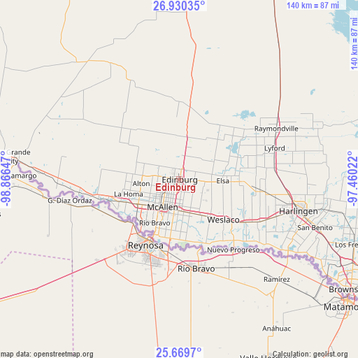
Edinburg GPS coordinates[2]
26° 18' 6.264" North, 98° 9' 48.024" West
| Map corner | latitude | longitude |
|---|---|---|
| Upper-left | 26.93035°, | -98.86647° |
| Center: | 26.30174°, | -98.16334° |
| Lower-right: | 25.6697°, | -97.46022° |
| Map W x H: | 140.2×140.2 km | = 87.1×87.1mi |
| max Lat: | 71.29058° ⇑98.2% North |
| Edinburg: | 26.30174° |
| min Lat: | ⇓1.8% South 19.06759° |
| min Long | Edinburg | max Long |
| -171.73463° | -98.16334° | -66.98998° |
| W 21.2%⇐ | ⇒78.8% E |
Elevation
Elevation of Edinburg is 35 m = 115 ft, and this is 259.8 m = 852 ft below average elevation for this country.
| Max E: |
3189 m = 10463 ft | 82.9% |
| Avg. | 294.8 m = 967 ft | |
| Edinburg | 35 m = 115 ft | |
Min E: |
-60 m = -197 ft | 17.1% |
See also: Edinburg elevation on elevation.city.
Geographical zone
Edinburg is located in North temperate zone (between Tropic of Cancer and the Arctic Circle). Distance of this Northern Tropic circle is 318.6 km =198 mi to South.| Distance of | km | miles | from Edinburg |
|---|---|---|---|
| North Pole | 7082.6 | 4400.9 | to North |
| Arctic Circle | 4476.7 | 2781.7 | to North |
| Tropic Cancer | 318.6 | 198 | to South |
| Equator | 2924.5 | 1817.2 | to South |


Nearby cities:
15 places around Edinburg: (largest is in red/bold)
• Alamo
13.7 km =8.5 mi,  162°
162°
• Alton
15 km =9.3 mi,  263°
263°
• Alton North (historical)
14.1 km =8.8 mi,  267°
267°
• César Chávez
4.8 km =3 mi,  87°
87°
• Doolittle
7.4 km =4.6 mi,  39°
39°
• La Blanca
12.6 km =7.8 mi, 94°
• Lopezville
7.1 km =4.4 mi,  177°
177°
• McAllen
12.8 km =8 mi,  211°
211°
• Muniz
8.9 km =5.5 mi,  124°
124°
• Murillo Colonia
7.1 km =4.4 mi,  135°
135°
• North Alamo
10 km =6.2 mi, 159°
• Nurillo
5.7 km =3.5 mi,  132°
132°
• Pharr
12.1 km =7.5 mi,  189°
189°
• San Carlos
9.1 km =5.7 mi, 94°
• San Juan
12.5 km =7.8 mi, 176°
Sources, notices
• [Note1] Compared only with cities in United States existing in our database
• [Src1] Map data: © OpenStreetMap contributors (CC-BY-SA)
• [Src2] Other city data from geonames.org with taken over terms of usage.
• [Src3] Geographical zone / Annual Mean Temperature by Robert A. Rohde @ Wikipedia
