Palmer geodata
Palmer (Texas) is a populated place; located in United States in America/Chicago (GMT-5) time zone. With population of 2,055 people, there are 11770 cities with bigger population in this country. Compared to other cities in United States, 87.4% of cities are located further ↑North; 74.9% of cities are located further →East and 62.1% of cities have higher elevation than Palmer. Note1


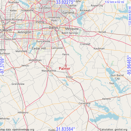
Palmer GPS coordinates[2]
32° 25' 52.5" North, 96° 40' 3.972" West
| Map corner | latitude | longitude |
|---|---|---|
| Upper-left | 33.02275°, | -97.3709° |
| Center: | 32.43125°, | -96.66777° |
| Lower-right: | 31.83584°, | -95.96465° |
| Map W x H: | 132×132 km | = 82×82mi |
| max Lat: | 71.29058° ⇑87.4% North |
| Palmer: | 32.43125° |
| min Lat: | ⇓12.6% South 19.06759° |
| min Long | Palmer | max Long |
| -171.73463° | -96.66777° | -66.98998° |
| W 25.1%⇐ | ⇒74.9% E |
Elevation
Elevation of Palmer is 144 m = 472 ft, and this is 150.8 m = 495 ft below average elevation for this country.
| Max E: |
3189 m = 10463 ft | 62.1% |
| Avg. | 294.8 m = 967 ft | |
| Palmer | 144 m = 472 ft | |
Min E: |
-60 m = -197 ft | 37.9% |
See also: United States elevation on elevation.city.
Geographical zone
Palmer is located in North temperate zone (between Tropic of Cancer and the Arctic Circle). Distance of this Northern Tropic circle is 1000.1 km =621.4 mi to South.| Distance of | km | miles | from Palmer |
|---|---|---|---|
| North Pole | 6401 | 3977.4 | to North |
| Arctic Circle | 3795.2 | 2358.2 | to North |
| Tropic Cancer | 1000.1 | 621.4 | to South |
| Equator | 3606 | 2240.7 | to South |


Nearby cities:
15 places around Palmer: (largest is in red/bold)
• Bardwell
18.2 km =11.3 mi,  188°
188°
• Bristol
9.8 km =6.1 mi,  69°
69°
• Combine
23 km =14.3 mi,  40°
40°
• Ennis
12 km =7.5 mi,  160°
160°
• Ferris
11.4 km =7.1 mi,  1°
1°
• Garrett
7.6 km =4.7 mi,  170°
170°
• Glenn Heights
22 km =13.7 mi,  306°
306°
• Lancaster
19.7 km =12.2 mi,  335°
335°
• Nash
22.9 km =14.2 mi,  216°
216°
• Oak Leaf
20.1 km =12.5 mi,  299°
299°
• Ovilla
23.1 km =14.4 mi, 297°
• Pecan Hill
12.7 km =7.9 mi, 299°
• Red Oak
16 km =9.9 mi, 306°
• Waxahachie
17.7 km =11 mi,  253°
253°
• Wilmer
17.6 km =10.9 mi,  354°
354°
Sources, notices
• [Note1] Compared only with cities in United States existing in our database
• [Src1] Map data: © OpenStreetMap contributors (CC-BY-SA)
• [Src2] Other city data from geonames.org with taken over terms of usage.
• [Src3] Geographical zone / Annual Mean Temperature by Robert A. Rohde @ Wikipedia
