Bristol geodata
Bristol (Texas) is a populated place; located in United States in America/Chicago (GMT-5) time zone. With population of 668 people, there are 18991 cities with bigger population in this country. Compared to other cities in United States, 87.3% of cities are located further ↑North; 74.6% of cities are located further →East and 59% of cities have higher elevation than Bristol. Note1


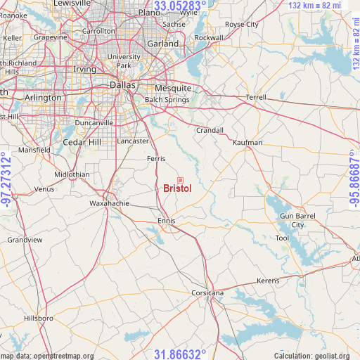
Bristol GPS coordinates[2]
32° 27' 41.508" North, 96° 34' 11.964" West
| Map corner | latitude | longitude |
|---|---|---|
| Upper-left | 33.05283°, | -97.27312° |
| Center: | 32.46153°, | -96.56999° |
| Lower-right: | 31.86632°, | -95.86687° |
| Map W x H: | 131.9×131.9 km | = 82×82mi |
| max Lat: | 71.29058° ⇑87.3% North |
| Bristol: | 32.46153° |
| min Lat: | ⇓12.7% South 19.06759° |
| min Long | Bristol | max Long |
| -171.73463° | -96.56999° | -66.98998° |
| W 25.4%⇐ | ⇒74.6% E |
Elevation
Elevation of Bristol is 160 m = 525 ft, and this is 134.8 m = 442 ft below average elevation for this country.
| Max E: |
3189 m = 10463 ft | 59% |
| Avg. | 294.8 m = 967 ft | |
| Bristol | 160 m = 525 ft | |
Min E: |
-60 m = -197 ft | 41% |
See also: United States elevation on elevation.city.
Geographical zone
Bristol is located in North temperate zone (between Tropic of Cancer and the Arctic Circle). Distance of this Northern Tropic circle is 1003.5 km =623.5 mi to South.| Distance of | km | miles | from Bristol |
|---|---|---|---|
| North Pole | 6397.7 | 3975.3 | to North |
| Arctic Circle | 3791.8 | 2356.1 | to North |
| Tropic Cancer | 1003.5 | 623.5 | to South |
| Equator | 3609.4 | 2242.8 | to South |


Nearby cities:
15 places around Bristol: (largest is in red/bold)
• Bardwell
24.5 km =15.2 mi,  208°
208°
• Combine
15.2 km =9.4 mi,  22°
22°
• Crandall
21.4 km =13.3 mi,  30°
30°
• Ennis
15.6 km =9.7 mi,  199°
199°
• Ferris
12.1 km =7.5 mi,  311°
311°
• Garrett
13.5 km =8.4 mi,  216°
216°
• Hutchins
24.8 km =15.4 mi,  327°
327°
• Lancaster
22.7 km =14.1 mi, 309°
• Oak Grove
24.9 km =15.5 mi,  70°
70°
• Palmer
9.8 km =6.1 mi,  249°
249°
• Pecan Hill
20.4 km =12.7 mi,  277°
277°
• Red Oak
22.9 km =14.2 mi,  285°
285°
• Scurry
18.8 km =11.7 mi, 70°
• Seagoville
20 km =12.4 mi,  8°
8°
• Wilmer
17.8 km =11.1 mi,  322°
322°
Sources, notices
• [Note1] Compared only with cities in United States existing in our database
• [Src1] Map data: © OpenStreetMap contributors (CC-BY-SA)
• [Src2] Other city data from geonames.org with taken over terms of usage.
• [Src3] Geographical zone / Annual Mean Temperature by Robert A. Rohde @ Wikipedia
