Pinehurst geodata
Pinehurst (Texas) is a populated place; located in United States in America/Chicago (GMT-5) time zone. With population of 2,081 people, there are 11691 cities with bigger population in this country. Compared to other cities in United States, 93.1% of cities are located further ↑North; 68.2% of cities are located further →East and 96.6% of cities have higher elevation than Pinehurst. Note1


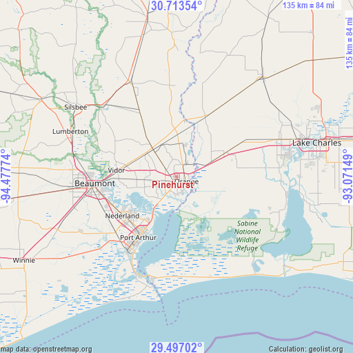
Pinehurst GPS coordinates[2]
30° 6' 25.74" North, 93° 46' 28.596" West
| Map corner | latitude | longitude |
|---|---|---|
| Upper-left | 30.71354°, | -94.47774° |
| Center: | 30.10715°, | -93.77461° |
| Lower-right: | 29.49702°, | -93.07149° |
| Map W x H: | 135.3×135.3 km | = 84.1×84.1mi |
| max Lat: | 71.29058° ⇑93.1% North |
| Pinehurst: | 30.10715° |
| min Lat: | ⇓6.9% South 19.06759° |
| min Long | Pinehurst | max Long |
| -171.73463° | -93.77461° | -66.98998° |
| W 31.8%⇐ | ⇒68.2% E |
Elevation
Elevation of Pinehurst is 7 m = 23 ft, and this is 287.8 m = 944 ft below average elevation for this country.
| Max E: |
3189 m = 10463 ft | 96.6% |
| Avg. | 294.8 m = 967 ft | |
| Pinehurst | 7 m = 23 ft | |
Min E: |
-60 m = -197 ft | 3.4% |
See also: United States elevation on elevation.city.
Geographical zone
Pinehurst is located in North temperate zone (between Tropic of Cancer and the Arctic Circle). Distance of this Northern Tropic circle is 741.7 km =460.9 mi to South.| Distance of | km | miles | from Pinehurst |
|---|---|---|---|
| North Pole | 6659.5 | 4138 | to North |
| Arctic Circle | 4053.6 | 2518.8 | to North |
| Tropic Cancer | 741.7 | 460.9 | to South |
| Equator | 3347.6 | 2080.1 | to South |


Nearby cities:
15 places around Pinehurst: (largest is in red/bold)
• Bridge City
11.8 km =7.3 mi,  215°
215°
• Central Gardens
26.2 km =16.3 mi,  241°
241°
• Deweyville
21.4 km =13.3 mi,  8°
8°
• Groves
22.4 km =13.9 mi, 217°
• Mauriceville
13.9 km =8.6 mi,  320°
320°
• Nederland
25.6 km =15.9 mi,  234°
234°
• Orange
4 km =2.5 mi,  113°
113°
• Pine Forest
26.3 km =16.3 mi,  288°
288°
• Port Arthur
29.5 km =18.3 mi,  213°
213°
• Port Neches
21.9 km =13.6 mi, 233°
• Rose City
26.7 km =16.6 mi,  268°
268°
• Starks
25.6 km =15.9 mi,  25°
25°
• Vidor
23.3 km =14.5 mi,  276°
276°
• Vinton
20.8 km =12.9 mi,  63°
63°
• West Orange
3.2 km =2 mi,  150°
150°
Sources, notices
• [Note1] Compared only with cities in United States existing in our database
• [Src1] Map data: © OpenStreetMap contributors (CC-BY-SA)
• [Src2] Other city data from geonames.org with taken over terms of usage.
• [Src3] Geographical zone / Annual Mean Temperature by Robert A. Rohde @ Wikipedia
