Plano geodata
Plano (Texas) is a populated place; located in United States in America/Chicago (GMT-5) time zone. With population of 283,558 people, there are 77 cities with bigger population in this country. Compared to other cities in United States, 85.1% of cities are located further ↑North; 74.9% of cities are located further →East and 52.2% of cities have lower elevation than Plano. Note1


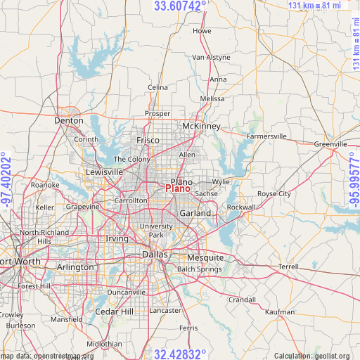
Plano GPS coordinates[2]
33° 1' 11.424" North, 96° 41' 56.004" West
| Map corner | latitude | longitude |
|---|---|---|
| Upper-left | 33.60742°, | -97.40202° |
| Center: | 33.01984°, | -96.69889° |
| Lower-right: | 32.42832°, | -95.99577° |
| Map W x H: | 131.1×131.1 km | = 81.5×81.5mi |
| max Lat: | 71.29058° ⇑85.1% North |
| Plano: | 33.01984° |
| min Lat: | ⇓14.9% South 19.06759° |
| min Long | Plano | max Long |
| -171.73463° | -96.69889° | -66.98998° |
| W 25.1%⇐ | ⇒74.9% E |
Elevation
Elevation of Plano is 207 m = 679 ft, and this is 87.8 m = 288 ft below average elevation for this country.
| Max E: |
3189 m = 10463 ft | 47.8% |
| Avg. | 294.8 m = 967 ft | |
| Plano | 207 m = 679 ft | |
Min E: |
-60 m = -197 ft | 52.2% |
See also: Plano elevation on elevation.city.
Geographical zone
Plano is located in North temperate zone (between Tropic of Cancer and the Arctic Circle). Distance of this Northern Tropic circle is 1065.5 km =662.1 mi to South.| Distance of | km | miles | from Plano |
|---|---|---|---|
| North Pole | 6335.6 | 3936.8 | to North |
| Arctic Circle | 3729.7 | 2317.5 | to North |
| Tropic Cancer | 1065.5 | 662.1 | to South |
| Equator | 3671.5 | 2281.4 | to South |


Nearby cities:
15 places around Plano: (largest is in red/bold)
• Addison
13.8 km =8.6 mi,  242°
242°
• Allen
9.6 km =6 mi,  15°
15°
• Carrollton
19.3 km =12 mi,  247°
247°
• Fairview
16.6 km =10.3 mi, 22°
• Frisco
18.6 km =11.6 mi,  321°
321°
• Garland
13.2 km =8.2 mi,  154°
154°
• Lucas
13.5 km =8.4 mi,  57°
57°
• Murphy
8 km =5 mi,  93°
93°
• Parker
8.2 km =5.1 mi, 61°
• Richardson
8.5 km =5.3 mi,  199°
199°
• Rowlett
18.1 km =11.2 mi,  135°
135°
• Sachse
10.8 km =6.7 mi,  116°
116°
• Saint Paul
14.1 km =8.8 mi,  80°
80°
• The Colony
19.1 km =11.9 mi,  293°
293°
• Wylie
14.9 km =9.3 mi, 92°
Sources, notices
• [Note1] Compared only with cities in United States existing in our database
• [Src1] Map data: © OpenStreetMap contributors (CC-BY-SA)
• [Src2] Other city data from geonames.org with taken over terms of usage.
• [Src3] Geographical zone / Annual Mean Temperature by Robert A. Rohde @ Wikipedia
