Garland geodata
Garland (Texas) is a populated place; located in United States in America/Chicago (GMT-5) time zone. With population of 236,897 people, there are 100 cities with bigger population in this country. Compared to other cities in United States, 85.5% of cities are located further ↑North; 74.8% of cities are located further →East and 56.4% of cities have higher elevation than Garland. Note1


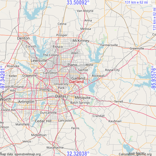
Garland GPS coordinates[2]
32° 54' 45.432" North, 96° 38' 19.968" West
| Map corner | latitude | longitude |
|---|---|---|
| Upper-left | 33.50092°, | -97.34201° |
| Center: | 32.91262°, | -96.63888° |
| Lower-right: | 32.32038°, | -95.93576° |
| Map W x H: | 131.3×131.3 km | = 81.6×81.6mi |
| max Lat: | 71.29058° ⇑85.5% North |
| Garland: | 32.91262° |
| min Lat: | ⇓14.5% South 19.06759° |
| min Long | Garland | max Long |
| -171.73463° | -96.63888° | -66.98998° |
| W 25.2%⇐ | ⇒74.8% E |
Elevation
Elevation of Garland is 174 m = 571 ft, and this is 120.8 m = 396 ft below average elevation for this country.
| Max E: |
3189 m = 10463 ft | 56.4% |
| Avg. | 294.8 m = 967 ft | |
| Garland | 174 m = 571 ft | |
Min E: |
-60 m = -197 ft | 43.6% |
See also: Garland elevation on elevation.city.
Geographical zone
Garland is located in North temperate zone (between Tropic of Cancer and the Arctic Circle). Distance of this Northern Tropic circle is 1053.6 km =654.7 mi to South.| Distance of | km | miles | from Garland |
|---|---|---|---|
| North Pole | 6347.5 | 3944.2 | to North |
| Arctic Circle | 3741.6 | 2324.9 | to North |
| Tropic Cancer | 1053.6 | 654.7 | to South |
| Equator | 3659.5 | 2273.9 | to South |


Nearby cities:
15 places around Garland: (largest is in red/bold)
• Addison
18.6 km =11.6 mi,  287°
287°
• Heath
17.5 km =10.9 mi,  118°
118°
• Highland Park
16.8 km =10.4 mi,  238°
238°
• Mesquite
16.6 km =10.3 mi,  167°
167°
• Murphy
11.6 km =7.2 mi,  11°
11°
• Parker
16 km =9.9 mi, 5°
• Plano
13.2 km =8.2 mi,  334°
334°
• Richardson
9.4 km =5.8 mi,  295°
295°
• Rockwall
16.9 km =10.5 mi,  82°
82°
• Rowlett
7.1 km =4.4 mi,  98°
98°
• Sachse
8.2 km =5.1 mi,  29°
29°
• Saint Paul
16.5 km =10.3 mi, 30°
• Sunnyvale
14.8 km =9.2 mi,  150°
150°
• University Park
16.6 km =10.3 mi,  245°
245°
• Wylie
14.7 km =9.1 mi,  39°
39°
Sources, notices
• [Note1] Compared only with cities in United States existing in our database
• [Src1] Map data: © OpenStreetMap contributors (CC-BY-SA)
• [Src2] Other city data from geonames.org with taken over terms of usage.
• [Src3] Geographical zone / Annual Mean Temperature by Robert A. Rohde @ Wikipedia
