Rancho Alegre geodata
Rancho Alegre (Texas) is a populated place; located in United States in America/Chicago (GMT-5) time zone. With population of 1,704 people, there are 12895 cities with bigger population in this country. Compared to other cities in United States, 97.1% of cities are located further ↑North; 78.7% of cities are located further →East and 74.9% of cities have higher elevation than Rancho Alegre. Note1


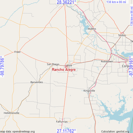
Rancho Alegre GPS coordinates[2]
27° 44' 30.084" North, 98° 5' 41.028" West
| Map corner | latitude | longitude |
|---|---|---|
| Upper-left | 28.36221°, | -98.79786° |
| Center: | 27.74169°, | -98.09473° |
| Lower-right: | 27.11762°, | -97.39161° |
| Map W x H: | 138.4×138.4 km | = 86×86mi |
| max Lat: | 71.29058° ⇑97.1% North |
| Rancho Alegre: | 27.74169° |
| min Lat: | ⇓2.9% South 19.06759° |
| min Long | Rancho Alegre | max Long |
| -171.73463° | -98.09473° | -66.98998° |
| W 21.3%⇐ | ⇒78.7% E |
Elevation
Elevation of Rancho Alegre is 72 m = 236 ft, and this is 222.8 m = 731 ft below average elevation for this country.
| Max E: |
3189 m = 10463 ft | 74.9% |
| Avg. | 294.8 m = 967 ft | |
| Rancho Alegre | 72 m = 236 ft | |
Min E: |
-60 m = -197 ft | 25.1% |
See also: United States elevation on elevation.city.
Geographical zone
Rancho Alegre is located in North temperate zone (between Tropic of Cancer and the Arctic Circle). Distance of this Northern Tropic circle is 478.7 km =297.5 mi to South.| Distance of | km | miles | from Rancho Alegre |
|---|---|---|---|
| North Pole | 6922.5 | 4301.4 | to North |
| Arctic Circle | 4316.6 | 2682.2 | to North |
| Tropic Cancer | 478.7 | 297.5 | to South |
| Equator | 3084.6 | 1916.7 | to South |


Nearby cities:
15 places around Rancho Alegre: (largest is in red/bold)
• Agua Dulce
18.8 km =11.7 mi,  76°
76°
• Alice
2.7 km =1.7 mi,  64°
64°
• Banquete
30.2 km =18.8 mi, 76°
• Benavides
34.7 km =21.6 mi,  242°
242°
• Bishop
33.9 km =21.1 mi,  120°
120°
• Coyote Acres
5 km =3.1 mi,  230°
230°
• Driscoll
34.9 km =21.7 mi,  102°
102°
• Kingsville
34.4 km =21.4 mi,  136°
136°
• Lake City
42.8 km =26.6 mi,  28°
28°
• North San Pedro
41.1 km =25.5 mi, 80°
• Orange Grove
28.5 km =17.7 mi, 32°
• Premont
42.5 km =26.4 mi,  183°
183°
• Robstown
42.2 km =26.2 mi, 82°
• San Diego
14.4 km =8.9 mi,  279°
279°
• Spring Gardens
34.9 km =21.7 mi,  86°
86°
Sources, notices
• [Note1] Compared only with cities in United States existing in our database
• [Src1] Map data: © OpenStreetMap contributors (CC-BY-SA)
• [Src2] Other city data from geonames.org with taken over terms of usage.
• [Src3] Geographical zone / Annual Mean Temperature by Robert A. Rohde @ Wikipedia
