Orange Grove geodata
Orange Grove (Texas) is a populated place; located in United States in America/Chicago (GMT-5) time zone. With population of 1,334 people, there are 14415 cities with bigger population in this country. Compared to other cities in United States, 96.7% of cities are located further ↑North; 78.3% of cities are located further →East and 76.7% of cities have higher elevation than Orange Grove. Note1


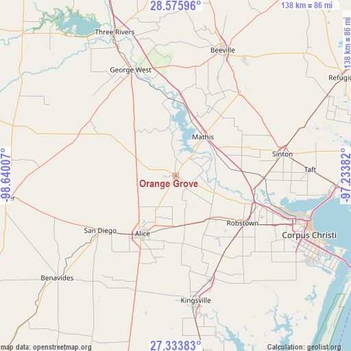
Orange Grove GPS coordinates[2]
27° 57' 24.048" North, 97° 56' 12.984" West
| Map corner | latitude | longitude |
|---|---|---|
| Upper-left | 28.57596°, | -98.64007° |
| Center: | 27.95668°, | -97.93694° |
| Lower-right: | 27.33383°, | -97.23382° |
| Map W x H: | 138.1×138.1 km | = 85.8×85.8mi |
| max Lat: | 71.29058° ⇑96.7% North |
| Orange Grove: | 27.95668° |
| min Lat: | ⇓3.3% South 19.06759° |
| min Long | Orange Grove | max Long |
| -171.73463° | -97.93694° | -66.98998° |
| W 21.7%⇐ | ⇒78.3% E |
Elevation
Elevation of Orange Grove is 62 m = 203 ft, and this is 232.8 m = 764 ft below average elevation for this country.
| Max E: |
3189 m = 10463 ft | 76.7% |
| Avg. | 294.8 m = 967 ft | |
| Orange Grove | 62 m = 203 ft | |
Min E: |
-60 m = -197 ft | 23.3% |
See also: United States elevation on elevation.city.
Geographical zone
Orange Grove is located in North temperate zone (between Tropic of Cancer and the Arctic Circle). Distance of this Northern Tropic circle is 502.6 km =312.3 mi to South.| Distance of | km | miles | from Orange Grove |
|---|---|---|---|
| North Pole | 6898.6 | 4286.6 | to North |
| Arctic Circle | 4292.7 | 2667.4 | to North |
| Tropic Cancer | 502.6 | 312.3 | to South |
| Equator | 3108.5 | 1931.5 | to South |


Nearby cities:
15 places around Orange Grove: (largest is in red/bold)
• Agua Dulce
19.7 km =12.2 mi,  171°
171°
• Alice
26.2 km =16.3 mi,  209°
209°
• Banquete
21.7 km =13.5 mi,  140°
140°
• Coyote Acres
33.3 km =20.7 mi,  215°
215°
• Driscoll
36.4 km =22.6 mi,  149°
149°
• Lake City
14.5 km =9 mi,  20°
20°
• Lakeshore Gardens-Hidden Acres
20.1 km =12.5 mi, 21°
• Mathis
18.7 km =11.6 mi,  34°
34°
• North San Pedro
30.3 km =18.8 mi,  124°
124°
• Odem
34.8 km =21.6 mi,  91°
91°
• Rancho Alegre
28.5 km =17.7 mi, 212°
• Robstown
32.2 km =20 mi,  125°
125°
• Saint Paul
40.6 km =25.2 mi,  67°
67°
• San Diego
36.6 km =22.7 mi,  234°
234°
• Spring Gardens
28.9 km =18 mi, 138°
Sources, notices
• [Note1] Compared only with cities in United States existing in our database
• [Src1] Map data: © OpenStreetMap contributors (CC-BY-SA)
• [Src2] Other city data from geonames.org with taken over terms of usage.
• [Src3] Geographical zone / Annual Mean Temperature by Robert A. Rohde @ Wikipedia
