Richwood geodata
Richwood (Texas) is a populated place; located in United States in America/Chicago (GMT-5) time zone. With population of 3,830 people, there are 8418 cities with bigger population in this country. Compared to other cities in United States, 95.1% of cities are located further ↑North; 72.1% of cities are located further →East and 93% of cities have higher elevation than Richwood. Note1


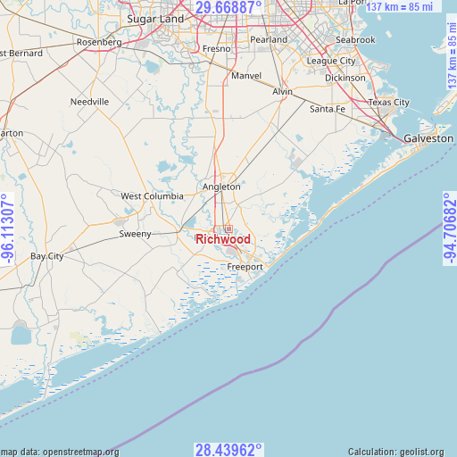
Richwood GPS coordinates[2]
29° 3' 21.888" North, 95° 24' 35.784" West
| Map corner | latitude | longitude |
|---|---|---|
| Upper-left | 29.66887°, | -96.11307° |
| Center: | 29.05608°, | -95.40994° |
| Lower-right: | 28.43962°, | -94.70682° |
| Map W x H: | 136.7×136.7 km | = 84.9×84.9mi |
| max Lat: | 71.29058° ⇑95.1% North |
| Richwood: | 29.05608° |
| min Lat: | ⇓4.9% South 19.06759° |
| min Long | Richwood | max Long |
| -171.73463° | -95.40994° | -66.98998° |
| W 27.9%⇐ | ⇒72.1% E |
Elevation
Elevation of Richwood is 11 m = 36 ft, and this is 283.8 m = 931 ft below average elevation for this country.
| Max E: |
3189 m = 10463 ft | 93% |
| Avg. | 294.8 m = 967 ft | |
| Richwood | 11 m = 36 ft | |
Min E: |
-60 m = -197 ft | 7% |
See also: United States elevation on elevation.city.
Geographical zone
Richwood is located in North temperate zone (between Tropic of Cancer and the Arctic Circle). Distance of this Northern Tropic circle is 624.8 km =388.2 mi to South.| Distance of | km | miles | from Richwood |
|---|---|---|---|
| North Pole | 6776.3 | 4210.6 | to North |
| Arctic Circle | 4170.4 | 2591.4 | to North |
| Tropic Cancer | 624.8 | 388.2 | to South |
| Equator | 3230.7 | 2007.5 | to South |


Nearby cities:
15 places around Richwood: (largest is in red/bold)
• Angleton
12.8 km =8 mi,  350°
350°
• Bailey Prairie
14.3 km =8.9 mi,  317°
317°
• Brazoria
15.5 km =9.6 mi,  265°
265°
• Clute
3.7 km =2.3 mi,  162°
162°
• Danbury
20.2 km =12.6 mi,  18°
18°
• Freeport
12.3 km =7.6 mi, 156°
• Holiday Lakes
20 km =12.4 mi,  328°
328°
• Jones Creek
10.7 km =6.6 mi,  204°
204°
• Lake Jackson
3.4 km =2.1 mi,  223°
223°
• Liverpool
29.5 km =18.3 mi,  25°
25°
• Oyster Creek
9.6 km =6 mi,  127°
127°
• Surfside Beach
17.1 km =10.6 mi,  136°
136°
• Sweeny
28.1 km =17.5 mi, 266°
• West Columbia
24.9 km =15.5 mi,  293°
293°
• Wild Peach Village
22 km =13.7 mi,  277°
277°
Sources, notices
• [Note1] Compared only with cities in United States existing in our database
• [Src1] Map data: © OpenStreetMap contributors (CC-BY-SA)
• [Src2] Other city data from geonames.org with taken over terms of usage.
• [Src3] Geographical zone / Annual Mean Temperature by Robert A. Rohde @ Wikipedia
