South Padre Island geodata
South Padre Island (Texas) is a populated place; located in United States in America/Chicago (GMT-5) time zone. With population of 2,884 people, there are 9839 cities with bigger population in this country. Compared to other cities in United States, 98.7% of cities are located further ↑North; 76.2% of cities are located further →East and 97.4% of cities have higher elevation than South Padre Island. Note1


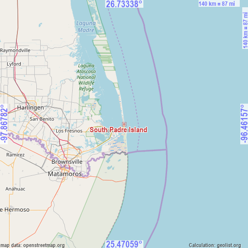
South Padre Island GPS coordinates[2]
26° 6' 13.284" North, 97° 9' 52.884" West
| Map corner | latitude | longitude |
|---|---|---|
| Upper-left | 26.73338°, | -97.86782° |
| Center: | 26.10369°, | -97.16469° |
| Lower-right: | 25.47059°, | -96.46157° |
| Map W x H: | 140.4×140.4 km | = 87.2×87.2mi |
| max Lat: | 71.29058° ⇑98.7% North |
| South Padre Island: | 26.10369° |
| min Lat: | ⇓1.3% South 19.06759° |
| min Long | South Padre Isl | max Long |
| -171.73463° | -97.16469° | -66.98998° |
| W 23.8%⇐ | ⇒76.2% E |
Elevation
Elevation of South Padre Island is 6 m = 20 ft, and this is 288.8 m = 948 ft below average elevation for this country.
| Max E: |
3189 m = 10463 ft | 97.4% |
| Avg. | 294.8 m = 967 ft | |
| South Padre Island | 6 m = 20 ft | |
Min E: |
-60 m = -197 ft | 2.6% |
See also: United States elevation on elevation.city.
Geographical zone
South Padre Island is located in North temperate zone (between Tropic of Cancer and the Arctic Circle). Distance of this Northern Tropic circle is 296.5 km =184.2 mi to South.| Distance of | km | miles | from South Padre Island |
|---|---|---|---|
| North Pole | 7104.6 | 4414.6 | to North |
| Arctic Circle | 4498.7 | 2795.4 | to North |
| Tropic Cancer | 296.5 | 184.2 | to South |
| Equator | 2902.5 | 1803.5 | to South |


Nearby cities:
15 places around South Padre Island: (largest is in red/bold)
• Cameron Park
34.8 km =21.6 mi,  243°
243°
• Cameron Park Colonia
34.6 km =21.5 mi, 244°
• Green Valley Farms
39.6 km =24.6 mi,  272°
272°
• Indian Lake
33.8 km =21 mi, 267°
• La Tina Ranch
33.5 km =20.8 mi,  292°
292°
• Laguna Heights
9.3 km =5.8 mi,  253°
253°
• Laguna Vista
12.5 km =7.8 mi, 268°
• Laureles
32.9 km =20.4 mi, 271°
• Los Fresnos
31.3 km =19.4 mi,  263°
263°
• Olmito
38 km =23.6 mi, 256°
• Port Isabel
5.5 km =3.4 mi,  232°
232°
• Reid Hope King
32 km =19.9 mi, 230°
• Reid Hope King Colonia
32.3 km =20.1 mi, 230°
• South Point
34.1 km =21.2 mi,  219°
219°
• Villa Pancho
35 km =21.7 mi, 225°
Sources, notices
• [Note1] Compared only with cities in United States existing in our database
• [Src1] Map data: © OpenStreetMap contributors (CC-BY-SA)
• [Src2] Other city data from geonames.org with taken over terms of usage.
• [Src3] Geographical zone / Annual Mean Temperature by Robert A. Rohde @ Wikipedia
