Springtown geodata
Springtown (Texas) is a populated place; located in United States in America/Chicago (GMT-5) time zone. With population of 2,811 people, there are 9978 cities with bigger population in this country. Compared to other cities in United States, 85.3% of cities are located further ↑North; 77.7% of cities are located further →East and 65.6% of cities have lower elevation than Springtown. Note1


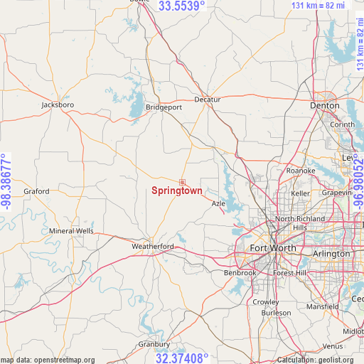
Springtown GPS coordinates[2]
32° 57' 57.456" North, 97° 41' 1.104" West
| Map corner | latitude | longitude |
|---|---|---|
| Upper-left | 33.5539°, | -98.38677° |
| Center: | 32.96596°, | -97.68364° |
| Lower-right: | 32.37408°, | -96.98052° |
| Map W x H: | 131.2×131.2 km | = 81.5×81.5mi |
| max Lat: | 71.29058° ⇑85.3% North |
| Springtown: | 32.96596° |
| min Lat: | ⇓14.7% South 19.06759° |
| min Long | Springtown | max Long |
| -171.73463° | -97.68364° | -66.98998° |
| W 22.3%⇐ | ⇒77.7% E |
Elevation
Elevation of Springtown is 265 m = 869 ft, and this is 29.8 m = 98 ft below average elevation for this country.
| Max E: |
3189 m = 10463 ft | 34.4% |
| Avg. | 294.8 m = 967 ft | |
| Springtown | 265 m = 869 ft | |
Min E: |
-60 m = -197 ft | 65.6% |
See also: United States elevation on elevation.city.
Geographical zone
Springtown is located in North temperate zone (between Tropic of Cancer and the Arctic Circle). Distance of this Northern Tropic circle is 1059.6 km =658.4 mi to South.| Distance of | km | miles | from Springtown |
|---|---|---|---|
| North Pole | 6341.6 | 3940.5 | to North |
| Arctic Circle | 3735.7 | 2321.3 | to North |
| Tropic Cancer | 1059.6 | 658.4 | to South |
| Equator | 3665.5 | 2277.6 | to South |


Nearby cities:
15 places around Springtown: (largest is in red/bold)
• Aurora
19.8 km =12.3 mi,  57°
57°
• Azle
15.1 km =9.4 mi,  121°
121°
• Boyd
16.7 km =10.4 mi,  41°
41°
• Briar
13.5 km =8.4 mi,  76°
76°
• Eagle Mountain
23.7 km =14.7 mi,  109°
109°
• Fairview
14.2 km =8.8 mi,  65°
65°
• Hudson Oaks
23.3 km =14.5 mi,  185°
185°
• Lakeside
23.9 km =14.9 mi,  131°
131°
• Newark
19 km =11.8 mi, 78°
• Pecan Acres
19.5 km =12.1 mi,  88°
88°
• Pelican Bay
16.2 km =10.1 mi, 107°
• Reno
10.2 km =6.3 mi,  103°
103°
• Rhome
22 km =13.7 mi, 63°
• Weatherford
25.3 km =15.7 mi,  204°
204°
• Willow Park
22.8 km =14.2 mi,  172°
172°
Sources, notices
• [Note1] Compared only with cities in United States existing in our database
• [Src1] Map data: © OpenStreetMap contributors (CC-BY-SA)
• [Src2] Other city data from geonames.org with taken over terms of usage.
• [Src3] Geographical zone / Annual Mean Temperature by Robert A. Rohde @ Wikipedia
