Weatherford geodata
Weatherford (Texas) is a seat of a second-order administrative division; located in United States in America/Chicago (GMT-5) time zone. With population of 28,742 people, there are 1738 cities with bigger population in this country. Compared to other cities in United States, 86.1% of cities are located further ↑North; 78% of cities are located further →East and 77.1% of cities have lower elevation than Weatherford. Note1


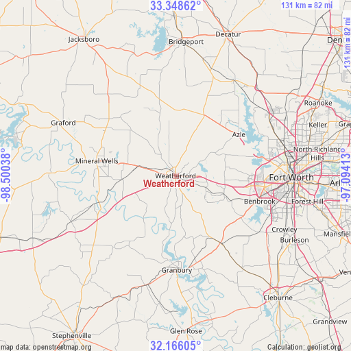
Weatherford GPS coordinates[2]
32° 45' 33.48" North, 97° 47' 50.1" West
| Map corner | latitude | longitude |
|---|---|---|
| Upper-left | 33.34862°, | -98.50038° |
| Center: | 32.7593°, | -97.79725° |
| Lower-right: | 32.16605°, | -97.09413° |
| Map W x H: | 131.5×131.5 km | = 81.7×81.7mi |
| max Lat: | 71.29058° ⇑86.1% North |
| Weatherford: | 32.7593° |
| min Lat: | ⇓13.9% South 19.06759° |
| min Long | Weatherford | max Long |
| -171.73463° | -97.79725° | -66.98998° |
| W 22%⇐ | ⇒78% E |
Elevation
Elevation of Weatherford is 328 m = 1076 ft, and this is 33.2 m = 109 ft above average elevation for this country.
| Max E: |
3189 m = 10463 ft | 22.9% |
| Weatherford | 328 m 1076 ft | |
| Avg. | 294.8 m = 967 ft | |
Min E: |
-60 m = -197 ft | 77.1% |
See also: United States elevation on elevation.city.
Geographical zone
Weatherford is located in North temperate zone (between Tropic of Cancer and the Arctic Circle). Distance of this Northern Tropic circle is 1036.6 km =644.1 mi to South.| Distance of | km | miles | from Weatherford |
|---|---|---|---|
| North Pole | 6364.6 | 3954.8 | to North |
| Arctic Circle | 3758.7 | 2335.5 | to North |
| Tropic Cancer | 1036.6 | 644.1 | to South |
| Equator | 3642.5 | 2263.3 | to South |


Nearby cities:
15 places around Weatherford: (largest is in red/bold)
• Aledo
19.6 km =12.2 mi,  111°
111°
• Annetta
12.6 km =7.8 mi,  116°
116°
• Annetta North
12.2 km =7.6 mi, 111°
• Annetta South
16.3 km =10.1 mi,  128°
128°
• Azle
27.9 km =17.3 mi,  57°
57°
• Cresson
30.3 km =18.8 mi,  146°
146°
• Hudson Oaks
8.5 km =5.3 mi,  91°
91°
• Lakeside
29.3 km =18.2 mi,  76°
76°
• Mineral Wells
30 km =18.6 mi,  280°
280°
• Oak Trail Shores
30.3 km =18.8 mi,  186°
186°
• Pelican Bay
31.7 km =19.7 mi, 55°
• Reno
29.1 km =18.1 mi,  44°
44°
• Springtown
25.3 km =15.7 mi,  24°
24°
• Western Lake
15.2 km =9.4 mi, 185°
• Willow Park
13.7 km =8.5 mi, 88°
Sources, notices
• [Note1] Compared only with cities in United States existing in our database
• [Src1] Map data: © OpenStreetMap contributors (CC-BY-SA)
• [Src2] Other city data from geonames.org with taken over terms of usage.
• [Src3] Geographical zone / Annual Mean Temperature by Robert A. Rohde @ Wikipedia
