Taft geodata
Taft (Texas) is a populated place; located in United States in America/Chicago (GMT-5) time zone. With population of 3,091 people, there are 9475 cities with bigger population in this country. Compared to other cities in United States, 96.7% of cities are located further ↑North; 76.9% of cities are located further →East and 88.2% of cities have higher elevation than Taft. Note1


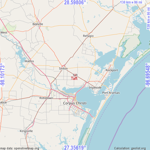
Taft GPS coordinates[2]
27° 58' 44.076" North, 97° 23' 54.96" West
| Map corner | latitude | longitude |
|---|---|---|
| Upper-left | 28.59806°, | -98.10173° |
| Center: | 27.97891°, | -97.3986° |
| Lower-right: | 27.35619°, | -96.69548° |
| Map W x H: | 138.1×138.1 km | = 85.8×85.8mi |
| max Lat: | 71.29058° ⇑96.7% North |
| Taft: | 27.97891° |
| min Lat: | ⇓3.3% South 19.06759° |
| min Long | Taft | max Long |
| -171.73463° | -97.3986° | -66.98998° |
| W 23.1%⇐ | ⇒76.9% E |
Elevation
Elevation of Taft is 20 m = 66 ft, and this is 274.8 m = 902 ft below average elevation for this country.
| Max E: |
3189 m = 10463 ft | 88.2% |
| Avg. | 294.8 m = 967 ft | |
| Taft | 20 m = 66 ft | |
Min E: |
-60 m = -197 ft | 11.8% |
See also: United States elevation on elevation.city.
Geographical zone
Taft is located in North temperate zone (between Tropic of Cancer and the Arctic Circle). Distance of this Northern Tropic circle is 505 km =313.8 mi to South.| Distance of | km | miles | from Taft |
|---|---|---|---|
| North Pole | 6896.1 | 4285 | to North |
| Arctic Circle | 4290.2 | 2665.8 | to North |
| Tropic Cancer | 505 | 313.8 | to South |
| Equator | 3111 | 1933.1 | to South |


Nearby cities:
15 places around Taft: (largest is in red/bold)
• Aransas Pass
25.6 km =15.9 mi,  107°
107°
• Corpus Christi
19.8 km =12.3 mi,  179°
179°
• Fulton
36.3 km =22.6 mi,  75°
75°
• Gregory
12.4 km =7.7 mi,  120°
120°
• Ingleside
21.5 km =13.4 mi, 121°
• Ingleside On-the-Bay
23.9 km =14.9 mi,  133°
133°
• North San Pedro
34.1 km =21.2 mi,  234°
234°
• Odem
18.3 km =11.4 mi,  260°
260°
• Portland
13.5 km =8.4 mi,  147°
147°
• Robstown
33.8 km =21 mi, 231°
• Rockport
34 km =21.1 mi, 82°
• Saint Paul
20.4 km =12.7 mi,  310°
310°
• Sinton
12.6 km =7.8 mi,  300°
300°
• Taft Southwest (historical)
0.7 km =0.4 mi,  218°
218°
• Woodsboro
29.9 km =18.6 mi,  14°
14°
Sources, notices
• [Note1] Compared only with cities in United States existing in our database
• [Src1] Map data: © OpenStreetMap contributors (CC-BY-SA)
• [Src2] Other city data from geonames.org with taken over terms of usage.
• [Src3] Geographical zone / Annual Mean Temperature by Robert A. Rohde @ Wikipedia
