Ingleside On-the-Bay geodata
Ingleside On-the-Bay (Texas) is a populated place; located in United States in America/Chicago (GMT-5) time zone. With population of 615 people, there are 19530 cities with bigger population in this country. Compared to other cities in United States, 96.9% of cities are located further ↑North; 76.4% of cities are located further →East and 96.6% of cities have higher elevation than Ingleside On-the-Bay. Note1


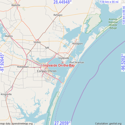
Ingleside On-the-Bay GPS coordinates[2]
27° 49' 46.092" North, 97° 13' 23.952" West
| Map corner | latitude | longitude |
|---|---|---|
| Upper-left | 28.44948°, | -97.92645° |
| Center: | 27.82947°, | -97.22332° |
| Lower-right: | 27.2059°, | -96.5202° |
| Map W x H: | 138.3×138.3 km | = 85.9×85.9mi |
| max Lat: | 71.29058° ⇑96.9% North |
| Ingleside On-the-Bay: | 27.82947° |
| min Lat: | ⇓3.1% South 19.06759° |
| min Long | Ingleside On-th | max Long |
| -171.73463° | -97.22332° | -66.98998° |
| W 23.6%⇐ | ⇒76.4% E |
Elevation
Elevation of Ingleside On-the-Bay is 7 m = 23 ft, and this is 287.8 m = 944 ft below average elevation for this country.
| Max E: |
3189 m = 10463 ft | 96.6% |
| Avg. | 294.8 m = 967 ft | |
| Ingleside On-the-Bay | 7 m = 23 ft | |
Min E: |
-60 m = -197 ft | 3.4% |
See also: United States elevation on elevation.city.
Geographical zone
Ingleside On-the-Bay is located in North temperate zone (between Tropic of Cancer and the Arctic Circle). Distance of this Northern Tropic circle is 488.4 km =303.5 mi to South.| Distance of | km | miles | from Ingleside On-the-Bay |
|---|---|---|---|
| North Pole | 6912.7 | 4295.4 | to North |
| Arctic Circle | 4306.8 | 2676.1 | to North |
| Tropic Cancer | 488.4 | 303.5 | to South |
| Equator | 3094.3 | 1922.7 | to South |


Nearby cities:
15 places around Ingleside On-the-Bay: (largest is in red/bold)
• Aransas Pass
11.4 km =7.1 mi,  39°
39°
• Corpus Christi
17.3 km =10.7 mi,  259°
259°
• Fulton
31.4 km =19.5 mi,  34°
34°
• Gregory
12.2 km =7.6 mi,  327°
327°
• Holiday Beach
43.1 km =26.8 mi, 28°
• Ingleside
5.5 km =3.4 mi,  12°
12°
• Lamar
40.6 km =25.2 mi, 31°
• Odem
37.8 km =23.5 mi,  290°
290°
• Port Aransas
16 km =9.9 mi,  88°
88°
• Portland
11.2 km =7 mi,  298°
298°
• Robstown
44 km =27.3 mi, 264°
• Rockport
26.9 km =16.7 mi, 37°
• Sinton
36.3 km =22.6 mi,  309°
309°
• Taft
23.9 km =14.9 mi, 313°
• Taft Southwest (historical)
23.9 km =14.9 mi, 312°
Sources, notices
• [Note1] Compared only with cities in United States existing in our database
• [Src1] Map data: © OpenStreetMap contributors (CC-BY-SA)
• [Src2] Other city data from geonames.org with taken over terms of usage.
• [Src3] Geographical zone / Annual Mean Temperature by Robert A. Rohde @ Wikipedia
