Westover Hills geodata
Westover Hills (Texas) is a populated place; located in United States in America/Chicago (GMT-5) time zone. With population of 721 people, there are 18489 cities with bigger population in this country. Compared to other cities in United States, 86.2% of cities are located further ↑North; 76.9% of cities are located further →East and 52.2% of cities have higher elevation than Westover Hills. Note1


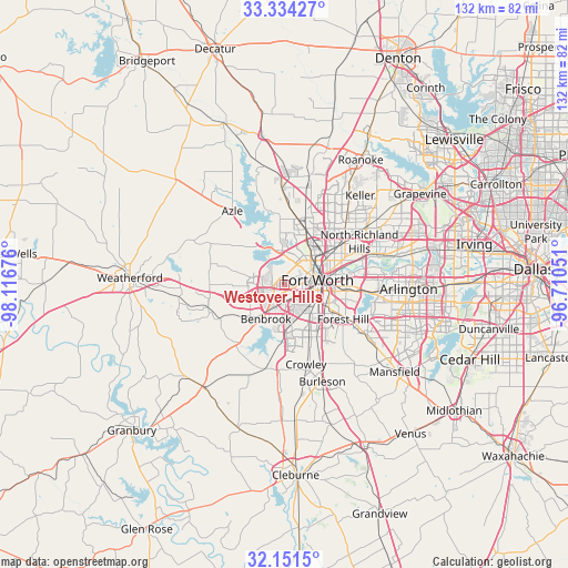
Westover Hills GPS coordinates[2]
32° 44' 41.46" North, 97° 24' 49.068" West
| Map corner | latitude | longitude |
|---|---|---|
| Upper-left | 33.33427°, | -98.11676° |
| Center: | 32.74485°, | -97.41363° |
| Lower-right: | 32.1515°, | -96.71051° |
| Map W x H: | 131.5×131.5 km | = 81.7×81.7mi |
| max Lat: | 71.29058° ⇑86.2% North |
| Westover Hills: | 32.74485° |
| min Lat: | ⇓13.8% South 19.06759° |
| min Long | Westover Hills | max Long |
| -171.73463° | -97.41363° | -66.98998° |
| W 23.1%⇐ | ⇒76.9% E |
Elevation
Elevation of Westover Hills is 190 m = 623 ft, and this is 104.8 m = 344 ft below average elevation for this country.
| Max E: |
3189 m = 10463 ft | 52.2% |
| Avg. | 294.8 m = 967 ft | |
| Westover Hills | 190 m = 623 ft | |
Min E: |
-60 m = -197 ft | 47.8% |
See also: United States elevation on elevation.city.
Geographical zone
Westover Hills is located in North temperate zone (between Tropic of Cancer and the Arctic Circle). Distance of this Northern Tropic circle is 1035 km =643.1 mi to South.| Distance of | km | miles | from Westover Hills |
|---|---|---|---|
| North Pole | 6366.2 | 3955.8 | to North |
| Arctic Circle | 3760.3 | 2336.5 | to North |
| Tropic Cancer | 1035 | 643.1 | to South |
| Equator | 3640.9 | 2262.3 | to South |


Nearby cities:
15 places around Westover Hills: (largest is in red/bold)
• Benbrook
9.1 km =5.7 mi,  208°
208°
• Blue Mound
14.2 km =8.8 mi,  29°
29°
• Eagle Mountain
16.8 km =10.4 mi,  350°
350°
• Edgecliff Village
11.7 km =7.3 mi,  145°
145°
• Everman
17.2 km =10.7 mi,  137°
137°
• Forest Hill
15.8 km =9.8 mi,  120°
120°
• Fort Worth
8.9 km =5.5 mi,  103°
103°
• Haltom City
14.8 km =9.2 mi,  65°
65°
• Lake Worth
7.3 km =4.5 mi,  336°
336°
• Lakeside
11.4 km =7.1 mi,  319°
319°
• River Oaks
4 km =2.5 mi, 26°
• Saginaw
13.6 km =8.5 mi,  19°
19°
• Sansom Park
6.9 km =4.3 mi,  8°
8°
• Westworth
1.4 km =0.9 mi, 10°
• White Settlement
4.5 km =2.8 mi,  291°
291°
Sources, notices
• [Note1] Compared only with cities in United States existing in our database
• [Src1] Map data: © OpenStreetMap contributors (CC-BY-SA)
• [Src2] Other city data from geonames.org with taken over terms of usage.
• [Src3] Geographical zone / Annual Mean Temperature by Robert A. Rohde @ Wikipedia
