Burke geodata
Burke (Virginia) is a populated place; located in United States in America/New_York (GMT-4) time zone. With population of 41,055 people, there are 1171 cities with bigger population in this country. Compared to other cities in United States, 56.6% of cities are located further ↑North; 79.6% of cities are located further ←West and 73.9% of cities have higher elevation than Burke. Note1


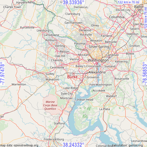
Burke GPS coordinates[2]
38° 47' 36.42" North, 77° 16' 17.94" West
| Map corner | latitude | longitude |
|---|---|---|
| Upper-left | 39.33936°, | -77.97478° |
| Center: | 38.79345°, | -77.27165° |
| Lower-right: | 38.24332°, | -76.56853° |
| Map W x H: | 121.9×121.9 km | = 75.7×75.7mi |
| max Lat: | 71.29058° ⇑56.6% North |
| Burke: | 38.79345° |
| min Lat: | ⇓43.4% South 19.06759° |
| min Long | Burke | max Long |
| -171.73463° | -77.27165° | -66.98998° |
| W 79.6%⇐ | ⇒20.4% E |
Elevation
Elevation of Burke is 78 m = 256 ft, and this is 216.8 m = 711 ft below average elevation for this country.
| Max E: |
3189 m = 10463 ft | 73.9% |
| Avg. | 294.8 m = 967 ft | |
| Burke | 78 m = 256 ft | |
Min E: |
-60 m = -197 ft | 26.1% |
See also: Burke elevation on elevation.city.
Geographical zone
Burke is located in North temperate zone (between Tropic of Cancer and the Arctic Circle). Distance of this Northern Tropic circle is 1707.5 km =1061 mi to South.| Distance of | km | miles | from Burke |
|---|---|---|---|
| North Pole | 5693.6 | 3537.8 | to North |
| Arctic Circle | 3087.7 | 1918.6 | to North |
| Tropic Cancer | 1707.5 | 1061 | to South |
| Equator | 4313.4 | 2680.2 | to South |


Nearby cities:
15 places around Burke: (largest is in red/bold)
• Annandale
7.7 km =4.8 mi,  57°
57°
• Fairfax
6.6 km =4.1 mi,  332°
332°
• Fairfax Station
4.7 km =2.9 mi,  280°
280°
• Kings Park
2.8 km =1.7 mi, 59°
• Kings Park West
3.1 km =1.9 mi,  318°
318°
• Laurel Hill
9.1 km =5.7 mi,  160°
160°
• Mantua
6.8 km =4.2 mi,  8°
8°
• Merrifield
9.8 km =6.1 mi,  23°
23°
• Newington
9.7 km =6 mi,  129°
129°
• North Springfield
5.9 km =3.7 mi,  78°
78°
• Oakton
10.1 km =6.3 mi,  345°
345°
• Ravensworth
4.6 km =2.9 mi, 75°
• Springfield
7.3 km =4.5 mi,  93°
93°
• West Springfield
5 km =3.1 mi,  117°
117°
• Woodburn
6.7 km =4.2 mi,  27°
27°
Sources, notices
• [Note1] Compared only with cities in United States existing in our database
• [Src1] Map data: © OpenStreetMap contributors (CC-BY-SA)
• [Src2] Other city data from geonames.org with taken over terms of usage.
• [Src3] Geographical zone / Annual Mean Temperature by Robert A. Rohde @ Wikipedia
