Centreville geodata
Centreville (Virginia) is a populated place; located in United States in America/New_York (GMT-4) time zone. With population of 71,135 people, there are 583 cities with bigger population in this country. Compared to other cities in United States, 56.3% of cities are located further ↑North; 79.1% of cities are located further ←West and 68.5% of cities have higher elevation than Centreville. Note1


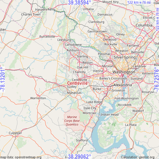
Centreville GPS coordinates[2]
38° 50' 25.404" North, 77° 25' 43.968" West
| Map corner | latitude | longitude |
|---|---|---|
| Upper-left | 39.38594°, | -78.13201° |
| Center: | 38.84039°, | -77.42888° |
| Lower-right: | 38.29062°, | -76.72576° |
| Map W x H: | 121.8×121.8 km | = 75.7×75.7mi |
| max Lat: | 71.29058° ⇑56.3% North |
| Centreville: | 38.84039° |
| min Lat: | ⇓43.7% South 19.06759° |
| min Long | Centreville | max Long |
| -171.73463° | -77.42888° | -66.98998° |
| W 79.1%⇐ | ⇒20.9% E |
Elevation
Elevation of Centreville is 110 m = 361 ft, and this is 184.8 m = 606 ft below average elevation for this country.
| Max E: |
3189 m = 10463 ft | 68.5% |
| Avg. | 294.8 m = 967 ft | |
| Centreville | 110 m = 361 ft | |
Min E: |
-60 m = -197 ft | 31.5% |
See also: Centreville elevation on elevation.city.
Geographical zone
Centreville is located in North temperate zone (between Tropic of Cancer and the Arctic Circle). Distance of this Northern Tropic circle is 1712.7 km =1064.2 mi to South.| Distance of | km | miles | from Centreville |
|---|---|---|---|
| North Pole | 5688.4 | 3534.6 | to North |
| Arctic Circle | 3082.5 | 1915.4 | to North |
| Tropic Cancer | 1712.7 | 1064.2 | to South |
| Equator | 4318.6 | 2683.5 | to South |


Nearby cities:
15 places around Centreville: (largest is in red/bold)
• Bull Run
10.1 km =6.3 mi,  231°
231°
• Chantilly
6 km =3.7 mi,  358°
358°
• Fairfax
10.6 km =6.6 mi,  86°
86°
• Fairfax Station
10 km =6.2 mi,  116°
116°
• Floris
10.8 km =6.7 mi,  7°
7°
• Greenbriar
4.4 km =2.7 mi,  33°
33°
• Kings Park West
11.9 km =7.4 mi,  104°
104°
• Loch Lomond
7.4 km =4.6 mi,  215°
215°
• Manassas
10.7 km =6.6 mi,  202°
202°
• Manassas Park
7.2 km =4.5 mi,  209°
209°
• Oak Hill
9.8 km =6.1 mi, 13°
• South Riding
11.1 km =6.9 mi,  324°
324°
• Sudley
8 km =5 mi, 228°
• West Gate
8.7 km =5.4 mi, 222°
• Yorkshire
5.5 km =3.4 mi, 197°
Sources, notices
• [Note1] Compared only with cities in United States existing in our database
• [Src1] Map data: © OpenStreetMap contributors (CC-BY-SA)
• [Src2] Other city data from geonames.org with taken over terms of usage.
• [Src3] Geographical zone / Annual Mean Temperature by Robert A. Rohde @ Wikipedia
