Manassas geodata
Manassas (Virginia) is a seat of a second-order administrative division; located in United States in America/New_York (GMT-4) time zone. With population of 41,764 people, there are 1148 cities with bigger population in this country. Compared to other cities in United States, 57% of cities are located further ↑North; 79% of cities are located further ←West and 71.1% of cities have higher elevation than Manassas. Note1


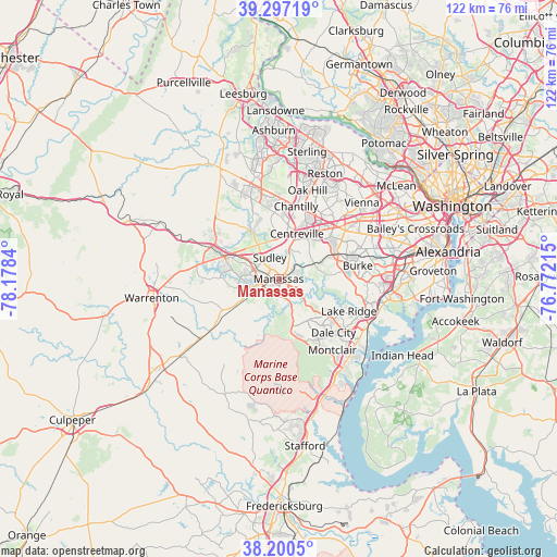
Manassas GPS coordinates[2]
38° 45' 3.42" North, 77° 28' 30.972" West
| Map corner | latitude | longitude |
|---|---|---|
| Upper-left | 39.29719°, | -78.1784° |
| Center: | 38.75095°, | -77.47527° |
| Lower-right: | 38.2005°, | -76.77215° |
| Map W x H: | 121.9×121.9 km | = 75.7×75.7mi |
| max Lat: | 71.29058° ⇑57% North |
| Manassas: | 38.75095° |
| min Lat: | ⇓43% South 19.06759° |
| min Long | Manassas | max Long |
| -171.73463° | -77.47527° | -66.98998° |
| W 79%⇐ | ⇒21% E |
Elevation
Elevation of Manassas is 94 m = 308 ft, and this is 200.8 m = 659 ft below average elevation for this country.
| Max E: |
3189 m = 10463 ft | 71.1% |
| Avg. | 294.8 m = 967 ft | |
| Manassas | 94 m = 308 ft | |
Min E: |
-60 m = -197 ft | 28.9% |
See also: Manassas elevation on elevation.city.
Geographical zone
Manassas is located in North temperate zone (between Tropic of Cancer and the Arctic Circle). Distance of this Northern Tropic circle is 1702.8 km =1058.1 mi to South.| Distance of | km | miles | from Manassas |
|---|---|---|---|
| North Pole | 5698.4 | 3540.8 | to North |
| Arctic Circle | 3092.5 | 1921.6 | to North |
| Tropic Cancer | 1702.8 | 1058.1 | to South |
| Equator | 4308.7 | 2677.3 | to South |


Nearby cities:
15 places around Manassas: (largest is in red/bold)
• Buckhall
4.4 km =2.7 mi,  119°
119°
• Bull Run
5.4 km =3.4 mi,  312°
312°
• Centreville
10.7 km =6.6 mi,  22°
22°
• Fairfax Station
14.1 km =8.8 mi,  66°
66°
• Gainesville
13 km =8.1 mi,  292°
292°
• Greenbriar
15.1 km =9.4 mi,  25°
25°
• Haymarket
15.5 km =9.6 mi,  295°
295°
• Independent Hill
13.2 km =8.2 mi,  165°
165°
• Linton Hall
8.7 km =5.4 mi,  276°
276°
• Loch Lomond
3.9 km =2.4 mi,  356°
356°
• Manassas Park
3.7 km =2.3 mi,  7°
7°
• Nokesville
10.8 km =6.7 mi,  237°
237°
• Sudley
5 km =3.1 mi,  337°
337°
• West Gate
4 km =2.5 mi,  331°
331°
• Yorkshire
5.3 km =3.3 mi, 26°
Sources, notices
• [Note1] Compared only with cities in United States existing in our database
• [Src1] Map data: © OpenStreetMap contributors (CC-BY-SA)
• [Src2] Other city data from geonames.org with taken over terms of usage.
• [Src3] Geographical zone / Annual Mean Temperature by Robert A. Rohde @ Wikipedia
